
Now Reading: Satellites watch as bomb cyclone hits northeast U.S. with snow and lightning
-
01
Satellites watch as bomb cyclone hits northeast U.S. with snow and lightning


Since Sunday (Feb. 22) evening, an aggressive blizzard has been inundating the northeast U.S. with piles of snow and wind speeds rivaling those of a hurricane. For instance, according to CNN, Montauk Point in New York reported the fastest winds as of Monday (Feb. 23) at 84 miles (135 kilometers) per hour.
And as it all unfolds, satellites in space are capturing overhead views of the blizzard, which has officially been categorized as what’s known as a “bomb cyclone.” Both terms are technical, with the National Weather Service classifying a “blizzard” as a storm that leads to winds in excess of 35 miles per hour (56 km/h) and visibility levels less than a quarter mile for at least 3 hours.
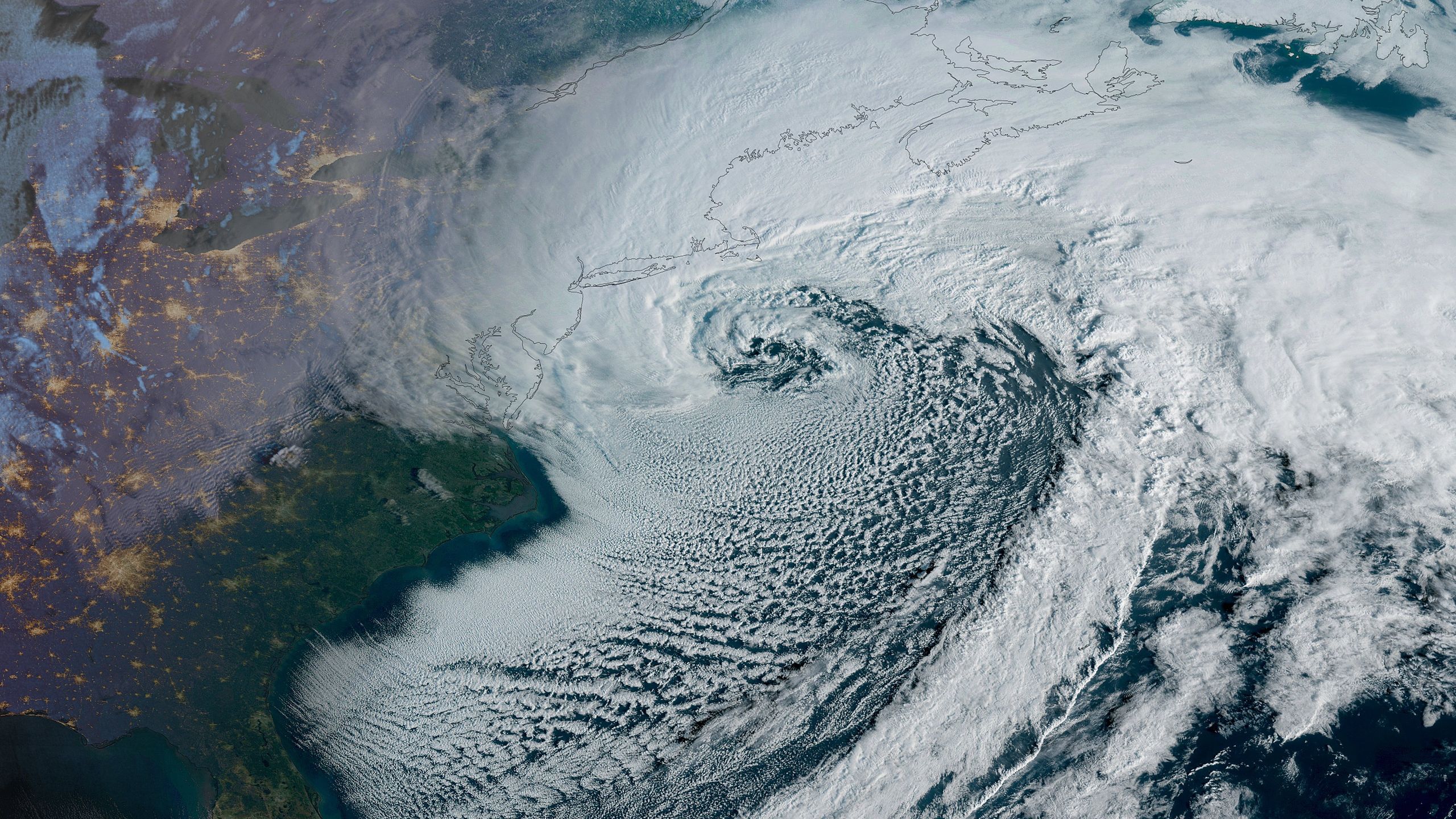
9:25am: The February 22-23, 2026 blizzard as seen from space courtesy of the GOES East satellite. pic.twitter.com/7pgXRbZXMRFebruary 23, 2026
In the image above, the GOES East satellite — part of the GOES-R program developed by NASA and the National Oceanic and Atmospheric Administration (NOAA) — reveals the spinning storm just off the coast of the northeast U.S. on Monday morning.
Impacted areas, as noticeable in this satellite footage, include Massachusetts, New York, New Jersey, Rhode Island and more. Several states have declared states of emergency and some areas have issued travel bans for nonessential trips until it’s safe for transportation to resume.
Lightning during a blizzard? Yes! This enhanced color imagery from @NOAA’s #GOESEast (#GOES19) 🛰️ shows #lightning flashing over the water as today’s powerful #noreaster rapidly intensified overnight. #Blizzard Warnings and #WinterStorm Warnings stretch from coastal Maryland… pic.twitter.com/zAHd70SG06February 23, 2026
GOES East also captured lightning strikes within the cyclone; this could be an indication of what’s known as “thundersnow.” According to the NOAA National Severe Storms Laboratory, this can happen in rare cases when there is “relatively strong instability and abundant moisture above the surface.” Local news in Boston indeed reported thundersnow appearing above Scituate, Massachusetts early on Monday.
Sunrise on the northern East Coast of the U.S. as a potent nor’easter brings heavy snow and strong winds to the region. pic.twitter.com/vRtV3zxFn1February 23, 2026
A stunning satellite shot of a powerful nor’easter. pic.twitter.com/C7TORWvhFJFebruary 23, 2026
As of Monday afternoon, the blizzard is still in full swing with multiple feet of snow predicted to befall the hardest-hit locations. As of 7:00 a.m. ET on Monday, Central Park in New York City had about 15 inches (38 centimeters) of snow and Newark had 18.3 (46 cm) inches, per the NWS. Swansea, Massachusetts had snowfall reaching 26.5 (67 cm) inches on Monday, according to the weather service.
Wind speeds continue to top the charts, nearly 60 million residents in affected areas are under weather warnings and hundreds of thousands have lost power. Many experts are suggesting this storm could be a historic one; for instance, this is the first blizzard warning for New York City in nine years.
A rapidly-intensifying nor’easter strikes the East Coast, where blizzard conditions are afflicting several heavily-populated metros. pic.twitter.com/qTx6lHbsQvFebruary 23, 2026


Related Posts

Stay Informed With the Latest & Most Important News
Previous Post
Next Post
Advertisement
-
 01Two Black Holes Observed Circling Each Other for the First Time
 -
 02From Polymerization-Enabled Folding and Assembly to Chemical Evolution: Key Processes for Emergence of Functional Polymers in the Origin of Life
 -
 03Astronomy 101: From the Sun and Moon to Wormholes and Warp Drive, Key Theories, Discoveries, and Facts about the Universe (The Adams 101 Series)
 -
 04Φsat-2 begins science phase for AI Earth images
 -
 05Hurricane forecasters are losing 3 key satellites ahead of peak storm season − a meteorologist explains why it matters
 -
 06True Anomaly hires former York Space executive as chief operating officer
 -
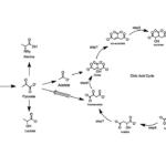 07Thermodynamic Constraints On The Citric Acid Cycle And Related Reactions In Ocean World Interiors