
Now Reading: Satellites watch glaciers melting in Patagonia | Space photo of the day for Oct. 22, 2025
-
01
Satellites watch glaciers melting in Patagonia | Space photo of the day for Oct. 22, 2025

Satellites watch glaciers melting in Patagonia | Space photo of the day for Oct. 22, 2025
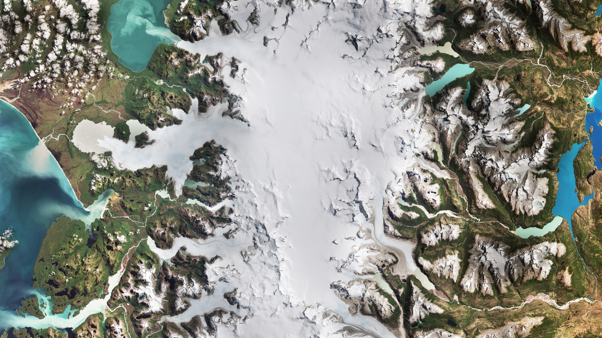
For decades, satellites orbiting hundreds of miles above Earth have provided scientists with a crucial vantage point to monitor our planet’s frozen landscapes. Missions like NASA’s Landsat and the European Space Agency‘s Copernicus Sentinel are particularly valuable for studying glaciers, vast dynamic rivers of ice that are sensitive to changes in temperature and precipitation.
What is it?
In a recent image released by the European Space Agency, the Copernicus Sentinel-2 satellite captured an image of Chile’s Laguna San Rafael National Park. Spanning approximately 10,500 square miles (17,000 square km), the park lies along Chile’s Pacific coast and in the Patagonian region. Its ice fields feed into 28 outlet glaciers, including the two largest glaciers seen in the image: San Rafael and San Quintin.
Where is it?
The Copernicus Sentinel-2 satellite is located around 477 miles (768 km) above Earth.

Why is it amazing?
Along with this recently taken image, the European Space Agency produced a similar image for comparison, taken in February 1987. Looking at the two satellite images, it’s easy to see the retreat of the glaciers over time, as the Earth’s climate continues to change.
The glaciers’ retreats have changed the landscape significantly, widening lakes and producing new bodies of water, proglacial lakes, a growing pool of meltwater. Simultaneously, their shrinking contributes directly to rising sea levels, one of the most profound and far-reaching consequences of climate change.
Want to learn more?
You can learn more about glacier melting and global warming.


Related Posts


Stay Informed With the Latest & Most Important News
Previous Post
Next Post

Advertisement
-
 01Two Black Holes Observed Circling Each Other for the First Time
 -
 02From Polymerization-Enabled Folding and Assembly to Chemical Evolution: Key Processes for Emergence of Functional Polymers in the Origin of Life
 -
 03Astronomy 101: From the Sun and Moon to Wormholes and Warp Drive, Key Theories, Discoveries, and Facts about the Universe (The Adams 101 Series)
 -
 04True Anomaly hires former York Space executive as chief operating officer
 -
 05Φsat-2 begins science phase for AI Earth images
 -
 06Hurricane forecasters are losing 3 key satellites ahead of peak storm season − a meteorologist explains why it matters
 -
 07Binary star systems are complex astronomical objects − a new AI approach could pin down their properties quickly