
Now Reading: Sea-level monitoring satellite Sentinel-6B sets sail
-
01
Sea-level monitoring satellite Sentinel-6B sets sail


23/07/2025
319 views
11 likes
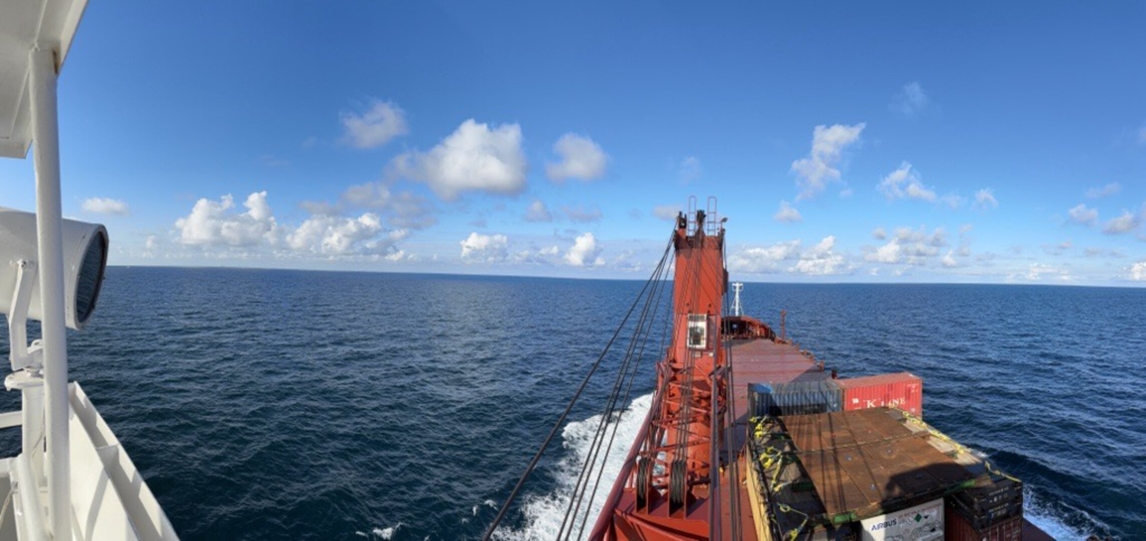
The next sea-level monitoring satellite, Copernicus Sentinel-6B, has begun its journey from Europe to the Vandenberg Space Force Base in California, where it is scheduled to launch in November. Carefully packed into a climate-controlled container, the satellite is currently crossing the Atlantic Ocean aboard the cargo ship Industrial Dolphin.
Sentinel-6B will follow in the footsteps of its predecessor, Sentinel-6 Michael Freilich, assuming the role of the reference radar altimetry mission to continue the vital record of sea-surface height measurements through at least 2030.
To ensure the highest data accuracy and continuity, Sentinel-6B will orbit in tandem with Sentinel-6 Michael Freilich for its first year, allowing for precise cross-calibration between the two instruments.
With the importance of monitoring sea-level rise so high on the global agenda, numerous organisations have been involved in making Copernicus Sentinel-6 the gold standard reference mission to take the record of sea-surface height measurements into the future, and to do this with greater precision than ever before.
So, while Sentinel-6 is one of the European Union’s family of Copernicus missions, its implementation is the result of an exceptional cooperation between the European Commission, ESA, NASA, Eumetsat, and NOAA, with support from the CNES French space agency.
The mission consists of two identical satellites: Sentinel-6 Michael Frelich, launched in late 2020, and Sentinel-6B, now en route to the Vandenberg Space Force Base launch site. These satellites continue the legacy of sea-surface height monitoring that began in 1992 with the French–US Topex Poseidon mission, followed by the Jason series of satellites.
ESA’s prime contracts for the build of the mission is Airbus Defence and Space in Germany with Thales Alenia Space in France responsible for the altimeter.
The mission builds on heritage from the French–US Jason series, ESA’s CryoSat and the Copernicus Sentinel-3 missions.
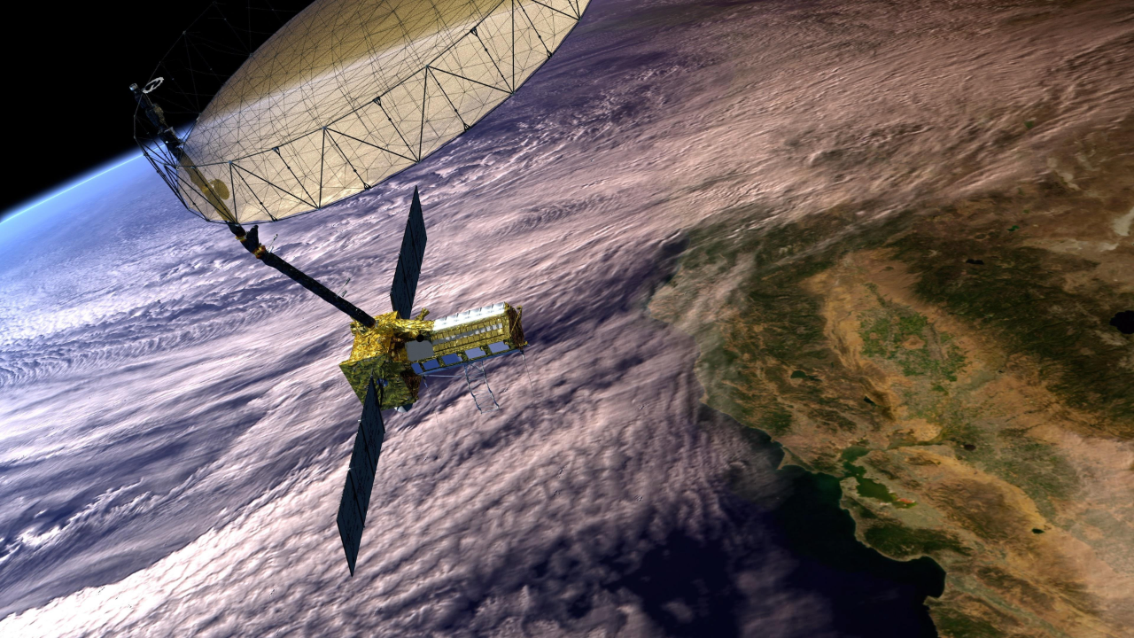
Developed by ESA, the main instrument is the Poseidon-4 dual-frequency (C-band and Ku-band) radar altimeter to measure sea-surface height, significant wave height and wind speed to support operational oceanography.
An advanced microwave radiometer, provided by NASA, supports Poseidon-4.
Water in the atmosphere affects the speed of the altimeter’s radar pulses – and therefore the estimates of sea-surface height. The advanced microwave radiometer determines the water content in the atmosphere for accurately correcting the radar measurements.
Planned to launch five years apart, Sentinel-6B is now preparing to take to the skies and later carry the baton from its predecessor, Sentinel-6 Michael Freilich.
Earlier this year, Sentinel-6B was removed from storage and underwent a series of checks at IABG in Ottobrunn, Germany.
It was then transported by lorry to Bremen, where it was loaded onto the Industrial Dolphin for a three-week voyage to Galveston, Texas.
Upon arrival, it will continue by road to NASA’s facilities at Vandenberg Space Force Base, where it will remain in storage until early October, when final launch preparations will begin.
With its November launch approaching, Sentinel-6B is poised to extend a legacy of over three decades of precision sea-level measurements – crucial to understanding and responding to one of the most pressing challenges of our time.


Related Posts

Stay Informed With the Latest & Most Important News
Previous Post
Next Post


Advertisement
-
 01Two Black Holes Observed Circling Each Other for the First Time
 -
 02From Polymerization-Enabled Folding and Assembly to Chemical Evolution: Key Processes for Emergence of Functional Polymers in the Origin of Life
 -
 03Astronomy 101: From the Sun and Moon to Wormholes and Warp Drive, Key Theories, Discoveries, and Facts about the Universe (The Adams 101 Series)
 -
 04True Anomaly hires former York Space executive as chief operating officer
 -
 05Φsat-2 begins science phase for AI Earth images
 -
 06Hurricane forecasters are losing 3 key satellites ahead of peak storm season − a meteorologist explains why it matters
 -
 07Binary star systems are complex astronomical objects − a new AI approach could pin down their properties quickly