
Now Reading: SMOS adds long-term view on carbon stored in forests
-
01
SMOS adds long-term view on carbon stored in forests


01/08/2025
159 views
7 likes
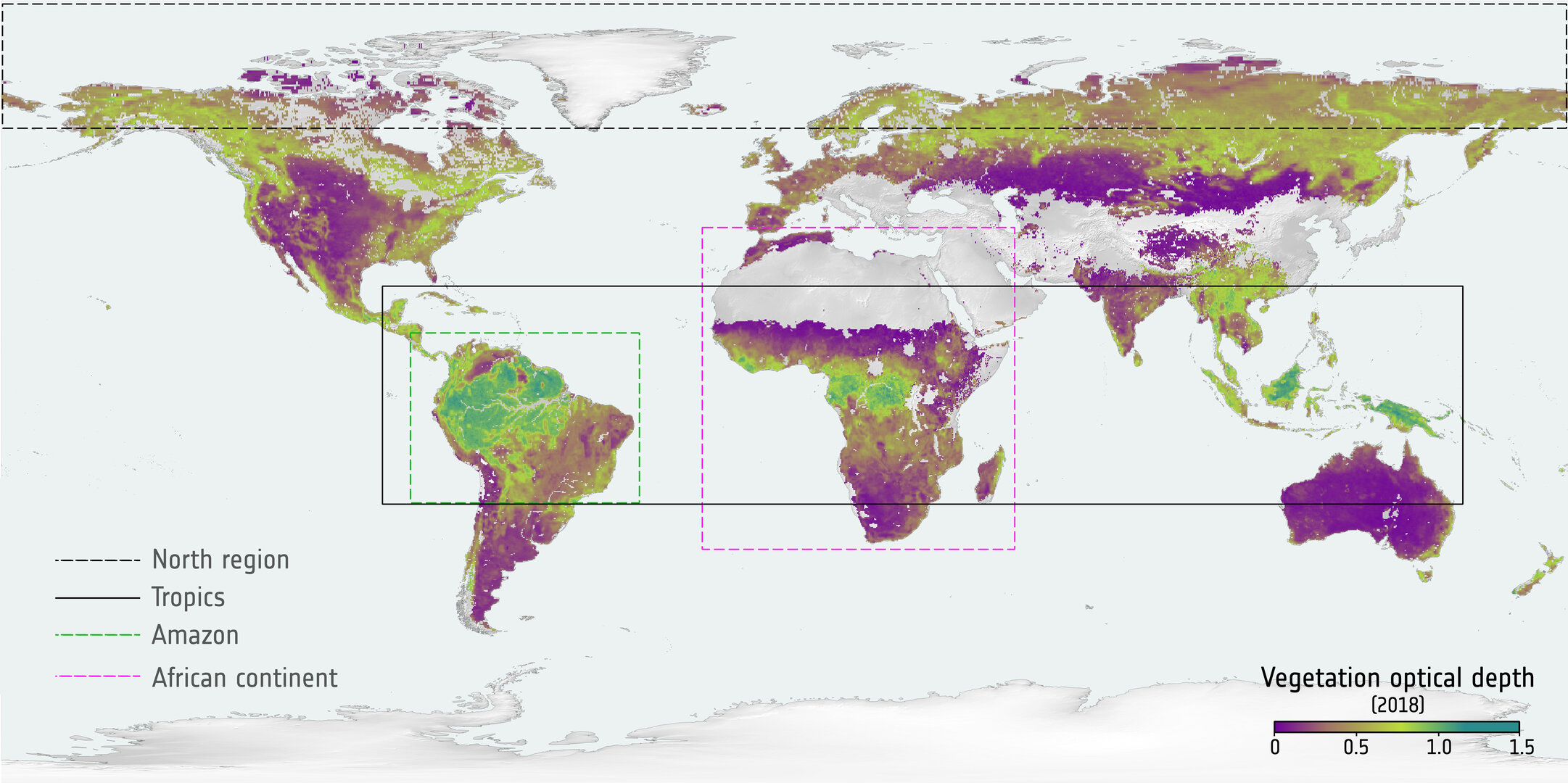
Data from ESA’s Soil Moisture and Ocean Salinity (SMOS) mission can be used to estimate how much carbon is stored in forests – and a study has improved our understanding of how reliable this proxy is and how long-term datasets from SMOS can help us to monitor this valuable resource.
Forests play a central role in the global carbon cycle as trees store carbon in their trunks, branches, roots and leaves. However, climate change and human activities can change the ability of forests to absorb carbon and the annual changes in these carbon stocks are highly variable in space and time around the globe. That’s why having continuous observations of the evolution of forest biomass over a long period is important for monitoring this essential climate variable.
The study published earlier this year in Earth System Science Data analysed a method for estimating forest biomass over a 15-year period using vegetation optical depth data from SMOS. This measurement – VOD for short – quantifies the opacity of a layer of vegetation, serving as a reliable proxy for above-ground biomass. Based on observations from 2011 to 2025, the study enhances our understanding of how SMOS-derived vegetation optical depth can be used to monitor carbon stored in forest ecosystems.
SMOS: doing far more than expected
SMOS, launched in 2009, is one of ESA’s Earth Explorer missions, which form the science and research element of the agency’s Earth Observation Programme.
The mission carries one instrument, the Microwave Imaging Radiometer, which operates in the L-band microwave range. Although SMOS was designed to derive global maps of soil moisture and ocean salinity, it has gone way beyond its original scientific brief and has provided data for other uses – such as to measure thin ice floating in the polar seas accurately enough for forecasting and ship routing. Its ability to measure vegetation optical depth, which can be used to understand more about biomass, has only been exploited in recent years and is one more example of how this mission has brought far more returns than expected.
Vegetation optical depth is a measure of the opacity of a layer of vegetation – in this case, forests. The level of opacity is determined by the amount of biomass, its structure and the water stored in the vegetation layer. It is a vital measure and due to its sensitivity to above-ground biomass it is also an indicator of the carbon stored. The study looked at the method used to analyse the relationship between forest biomass and measurements of vegetation optical depth.
Matthias Drusch, Land Surfaces Principal Scientist at ESA, noted that SMOS is able to detect how the microwave radiation signal from its instrument gets weaker when it passes through vegetation. “That tells us about total mass: dry biomass plus water content. It’s not direct, but it’s very useful.”
And ESA’s SMOS and Biomass Mission Manager, Klaus Scipal, explained why the method of using the vegetation optical depth data from SMOS needed to be analysed and better understood. He said, “Over the SMOS time series, you can spot major trends – big droughts, floods, or shifts in vegetation structure – but interpreting them isn’t always straightforward. Because the signal includes both biomass and water, we need to be cautious about what we’re actually seeing.”
However, while satellite observations from missions such as SMOS and Biomass can analyse vegetation properties on a large scale, continuous ground reference observations are also needed to validate the data. Paul Vermunt, a scientist from the University of Twente in the Netherlands, is researching forest biomass from the ground, as part of a project funded by the ESA Living Planet Fellowship. He emphasised the need for both ground-based data and for long-term datasets, “You need long time-series, but also a way to interpret them. That’s why we’re combining satellite data with on-the-ground measurements. The idea is to link what we see from space with what’s happening inside forests and even individual trees.”
More detailed data from Biomass
ESA’s Biomass mission, launched in April this year, also provides data on the biomass content of forests. Like SMOS, Biomass also has a radar remote-sensing instrument, but it is able to detect radio frequencies at longer wavelengths than SMOS. While SMOS detects wavelenths in the L-band and can penetrate some vegetation, the Biomass mission detects longer wavelengths in the P-band. This enables it to penetrate deeper into forests and capture far more accurate data on their biomass composition, as well as ground deformation.
Matthias said, “Biomass gives us detailed structural data, especially in the tropics. But it doesn’t cover the globe and lacks a long time record. If we want maps without gaps, we have to combine multiple satellites – and that’s only possible if we understand the uncertainties in each.”
And Klaus added, “Biomass has a much finer resolution than SMOS, so it helps us zoom in on the structural details. But to see long-term trends, you still need SMOS. Together, they tell us more than either one alone.”
The data on above-ground biomass derived from SMOS is consistent with data on biomass from ESA’s Climate Change Initiative.
The Biomass mission will be able to build on this knowledge and will be able to provide more detail on the health of Earth’s organic matter in the future. Klaus noted, “SMOS allows us to look on long-term trends on a global scale – and Biomass is now zooming in on spatial details and specifically at structural changes in the canopy.”


Related Posts
Stay Informed With the Latest & Most Important News
Previous Post
Next Post


Advertisement
-
 01Two Black Holes Observed Circling Each Other for the First Time
 -
 02From Polymerization-Enabled Folding and Assembly to Chemical Evolution: Key Processes for Emergence of Functional Polymers in the Origin of Life
 -
 03Astronomy 101: From the Sun and Moon to Wormholes and Warp Drive, Key Theories, Discoveries, and Facts about the Universe (The Adams 101 Series)
 -
 04True Anomaly hires former York Space executive as chief operating officer
 -
 05Φsat-2 begins science phase for AI Earth images
 -
 06Hurricane forecasters are losing 3 key satellites ahead of peak storm season − a meteorologist explains why it matters
 -
 07Binary star systems are complex astronomical objects − a new AI approach could pin down their properties quickly