
Now Reading: Southern Europe’s land and sea sizzles
-
01
Southern Europe’s land and sea sizzles

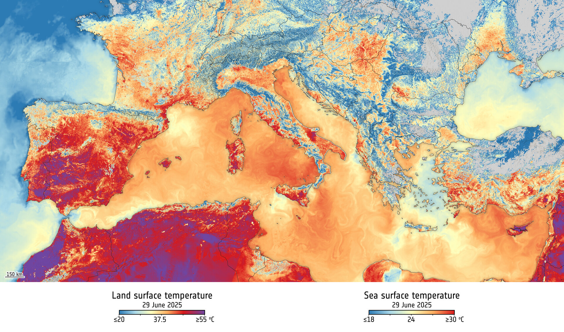

A powerful heatwave has been gripping large parts of southern Europe and North Africa, pushing air temperatures beyond seasonal norms and triggering widespread health and wildfire alerts. Among the hardest-hit countries are Spain, France, Italy, Greece, Cyprus, and Algeria.
This image, a mosaic from five overlapping orbital passes in the morning of 29 June 2025, was captured by the Copernicus Sentinel-3 mission’s Sea and Land Surface Temperature Radiometer. As the instrument’s name suggests, the image reveals the temperature of the land surface, not air temperature. Unlike measurements of air temperature, this satellite instrument measures the actual thermal energy emitted from Earth’s surface, which typically registers higher than air temperatures. Click on ‘download’ (above) for the ‘hi-res’ annotated image.
It’s not just the surface of the land that’s hot, so too is the sea surface of the Mediterranean Sea – as the image also shows using information from the Copernicus Marine Service.
Monitoring land-surface temperature is crucial for understanding and forecasting weather and climate patterns, tracking wildfire risks, supporting farmers with irrigation planning, and guiding urban design to better mitigate heat.
The current heatwave is being driven by a high-pressure system stalled over Western Europe, commonly referred to as a ‘heat dome’. This system acts like a lid, trapping hot, dry air and amplifying temperatures over time. As it shifts eastward, it is also drawing in additional hot air from North Africa, further exacerbating the extreme heat across the region.


Related Posts

Stay Informed With the Latest & Most Important News
Previous Post
Next Post


Advertisement
-
 01Two Black Holes Observed Circling Each Other for the First Time
 -
 02From Polymerization-Enabled Folding and Assembly to Chemical Evolution: Key Processes for Emergence of Functional Polymers in the Origin of Life
 -
 03Astronomy 101: From the Sun and Moon to Wormholes and Warp Drive, Key Theories, Discoveries, and Facts about the Universe (The Adams 101 Series)
 -
 04True Anomaly hires former York Space executive as chief operating officer
 -
 05Φsat-2 begins science phase for AI Earth images
 -
 06Hurricane forecasters are losing 3 key satellites ahead of peak storm season − a meteorologist explains why it matters
 -
 07Binary star systems are complex astronomical objects − a new AI approach could pin down their properties quickly