
Now Reading: SpaceEye-T: 25 cm Satellite Imagery and Tasking Now Available Through Pacific Geomatics Limited
-
01
SpaceEye-T: 25 cm Satellite Imagery and Tasking Now Available Through Pacific Geomatics Limited

SpaceEye-T: 25 cm Satellite Imagery and Tasking Now Available Through Pacific Geomatics Limited
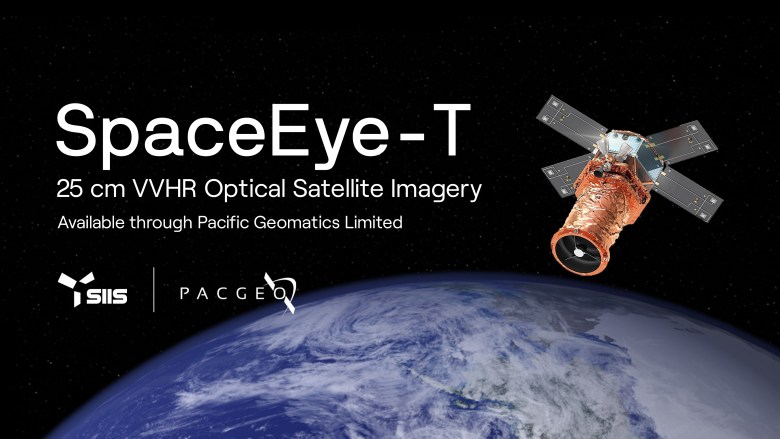

Victoria, Canada / Daejeon, South Korea – March 24, 2026 – Canadian and international organizations can now access SpaceEye-T imagery and tasking services through Pacific Geomatics Limited, one of the first authorized users of the satellite, in partnership with SI Imaging Services (SIIS).
SpaceEye-T is a next-generation VVHR (very very high-resolution) optical satellite with 25 cm native resolution, the finest commercially available optical satellite in orbit.
Features that blend together at coarser resolutions are now individually identifiable, allowing users to reduce uncertainty and make faster, higher-confidence decisions.
Where VVHR Detail Shows Up
At 25 cm, analysts can tell the difference between individual vehicles at a facility, confirm whether a structure has changed between collections, or spot ground disturbance that would be ambiguous at 30 cm – 50 cm. Whether it’s site monitoring for defence, change detection for environmental projects, or infrastructure assessment, the value of SpaceEye-T’s 25 cm VVHR imagery, put simply, is that more pixels equals better insights.
Collection Capacity and Imaging Modes
With a collection capacity of up to 300,000 km² each day, SpaceEye-T is fit for persistent monitoring of critical sites as well as short-notice priorities. Beyond the 25 cm panchromatic band, SpaceEye-T also collects 1 m four-band multispectral imagery, that supports land classification, vegetation analysis, and other applications that depend on detailed spectral data.
Imaging modes include strip collection for corridors and linear features, wide area collection for broader regional coverage, and stereo collection for 3D terrain modelling and elevation projects.
SpaceEye-T at a Glance
- Sensor Type: Optical
- Resolution (PAN): 25 cm
- Resolution (MS): 1 m
- Spectral Bands: Panchromatic + 4-band multispectral (VNIR)
- Swath Width: 12 km
- Daily Collection Capacity: Up to 300,000 km²
- Imaging Modes: Strip, Wide Area, Stereo
- Orbit: Sun-synchronous, 500 km altitude
- Operator: SI Imaging Services (SIIS)
Assured Tasking for Time-Critical Insights
Not every collection can wait for optimal conditions. Some programs run on fixed cycles whether it’s a reporting deadline, an operational window, or a time-sensitive tasking requirement. Assured tasking provides a guaranteed collection attempt within a set window, so decision-makers can plan around a schedule instead of waiting on availability.
About Pacific Geomatics Limited
Pacific Geomatics Limited (PacGeo) is a privately owned Canadian corporation that has been providing satellite imagery and geospatial solutions since 1994. As a vendor-agnostic provider, PacGeo works with the most advanced commercially available optical and radar satellites to deliver data, information products, and expert guidance to clients worldwide. PacGeo serves Government, Defence, Mining, Oil & Gas, Forestry, and Environmental sectors, and is a trusted provider of high-resolution satellite imagery for the Canadian government and its defence, intelligence, and security sectors.
About SI Imaging Services
SI Imaging Services (SIIS) is a global provider of satellite imagery, specializing in commercial Earth observation data. SIIS distributes imagery from Korea’s KOMPSAT series, developed by the Korea Aerospace Research Institute (KARI), and operates SpaceEye-T, developed by the Satrec Initiative Group.
Consult Our Experts
To discuss whether SpaceEye-T 25 cm imagery is the right fit for your requirements, contact Pacific Geomatics Limited to review feasibility, collection options, and tasking approach.
Learn More
Website: https://pacgeo.com/
LinkedIn: https://www.linkedin.com/company/pacgeo/
Mailing list: https://pacgeo.com/join-mailing-list


Related Posts


Stay Informed With the Latest & Most Important News
Previous Post
Next Post


Advertisement
-
 01Two Black Holes Observed Circling Each Other for the First Time
 -
 02From Polymerization-Enabled Folding and Assembly to Chemical Evolution: Key Processes for Emergence of Functional Polymers in the Origin of Life
 -
 03Astronomy 101: From the Sun and Moon to Wormholes and Warp Drive, Key Theories, Discoveries, and Facts about the Universe (The Adams 101 Series)
 -
 04True Anomaly hires former York Space executive as chief operating officer
 -
 05Φsat-2 begins science phase for AI Earth images
 -
 06Hurricane forecasters are losing 3 key satellites ahead of peak storm season − a meteorologist explains why it matters
 -
 07Binary star systems are complex astronomical objects − a new AI approach could pin down their properties quickly