
Now Reading: Spectroscopic Mapping of Callisto with HST/STIS and Implications for its Surface Composition
-
01
Spectroscopic Mapping of Callisto with HST/STIS and Implications for its Surface Composition

Spectroscopic Mapping of Callisto with HST/STIS and Implications for its Surface Composition
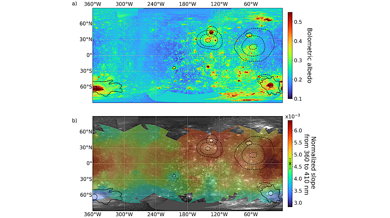

Maps showing Callisto’s bolometric albedo (a; from Camarca et al. 2023) compared with the spectral slope from 360 to 410 nm (b), which measures the strength of the near-UV downturn (redder slope = stronger downturn). — astro-ph.EP
We present global, spatially resolved ultraviolet-visible spectra of Callisto obtained with HST/STIS and explore possible compositions of Callisto’s surface material.
We map the strength of a widespread downturn toward the near-UV and the NIR spectral slope from 700 to 1000 nm, which varies from slightly blue (reflectance decreasing from 700 to 1000 nm) to red (reflectance increasing) across Callisto’s surface.
Globally, bright water-ice-rich regions tend to have neutral or blue NIR slopes and a shallower near-UV downturn, while darker material is associated with red NIR slopes and stronger near-UV absorption. Broad absorptions near 820 and 930 nm are spatially correlated with the Asgard and Valhalla impact basins and may be associated with iron-bearing silicates. An absorption edge near 275 nm maps primarily to Callisto’s trailing hemisphere, and a 320 nm absorption most prevalent within and surrounding Asgard and Valhalla may be related to organics.
We report two new absorption features near 230 and 450 nm which might be attributed to irradiated NaCl. We find little evidence for sulfur-bearing species at UV-visible wavelengths and suggest that a 280 nm band seen only in leading/trailing hemisphere ratio spectra and previously attributed to SO2 is better explained as a consequence of dividing the unrelated 320 nm leading hemisphere band by the trailing hemisphere 275 nm absorption edge.
Spatial variations in spectral features suggest that Callisto’s dark material composition varies regionally, reflecting a mix of endogenic and exogenic sources and radiolytic alteration.

Maps showing Callisto’s bolometric albedo (a; from Camarca et al. 2023) compared with the spectral slope from 360 to 410 nm (b), which measures the strength of the near-UV downturn (redder slope = stronger downturn). The per-pixel estimated 1σ error on the 360 to 410 nm slope ranged from ±4.9×10⁻⁵ to ±2.2×10⁻⁴ , and the minimum (black) and maximum (grey) estimated error is shown on the colorbar. On both maps, the large ringed basins Valhalla (56◦W , 16◦N ), Asgard (140◦W , 32◦N ), Utgard (134◦W , 45◦N ), and Adlinda (36◦W , 48◦S ) are outlined with black dashed lines. For Valhalla, Asgard, and Adlinda, the central, inner, and outer rings are shown, based on the geologic map from Greeley et al. (2000). A few young, bright impact features are also indicated in solid black, along with Heimdall (357◦W , 65.5◦S ) and Lofn (22◦W , 56.5◦S ) craters and their relatively extensive ejecta. The scatter plots (c), produced by degrading the spatial resolution of the albedo map to match the HST/STIS observations, reveal the moderate correlation between the bolometric albedo and near-UV downturn on Callisto’s leading and trailing hemispheres and the Pearson correlation coefficient (R) is shown on each plot. The colorbar indicates the NIR slope (700-1000 nm) mapped in Figure 3. — astro-ph.EP
M. Ryleigh Davis, Samantha K. Trumbo, Michael E. Brown, Matthew Belyakov
Comments: 33 pages, 11 figures, accepted in PSJ
Subjects: Earth and Planetary Astrophysics (astro-ph.EP)
Cite as: arXiv:2506.00151 [astro-ph.EP] (or arXiv:2506.00151v1 [astro-ph.EP] for this version)
https://doi.org/10.48550/arXiv.2506.00151
Focus to learn more
Submission history
From: M. Ryleigh Davis
[v1] Fri, 30 May 2025 18:42:29 UTC (47,740 KB)
https://arxiv.org/abs/2506.00151
Astrobiology, Astrochemistry,


Related Posts

Stay Informed With the Latest & Most Important News


Advertisement
-
 01Two Black Holes Observed Circling Each Other for the First Time
 -
 02From Polymerization-Enabled Folding and Assembly to Chemical Evolution: Key Processes for Emergence of Functional Polymers in the Origin of Life
 -
 03Astronomy 101: From the Sun and Moon to Wormholes and Warp Drive, Key Theories, Discoveries, and Facts about the Universe (The Adams 101 Series)
 -
 04True Anomaly hires former York Space executive as chief operating officer
 -
 05Φsat-2 begins science phase for AI Earth images
 -
 06Hurricane forecasters are losing 3 key satellites ahead of peak storm season − a meteorologist explains why it matters
 -
 07Binary star systems are complex astronomical objects − a new AI approach could pin down their properties quickly