
Now Reading: Total solar eclipse 2028: Everything you need to know about totality in Australia and New Zealand
-
01
Total solar eclipse 2028: Everything you need to know about totality in Australia and New Zealand

Total solar eclipse 2028: Everything you need to know about totality in Australia and New Zealand

On July 22, 2028, the moon’s shadow will cut a 143-mile-wide (230 kilometer) path across Australia and New Zealand. According to NASA, it will mark the first total solar eclipse visible from Sydney since 1857 and the last until 2858, making it a once-in-a-lifetime event for the city’s 5 million residents.
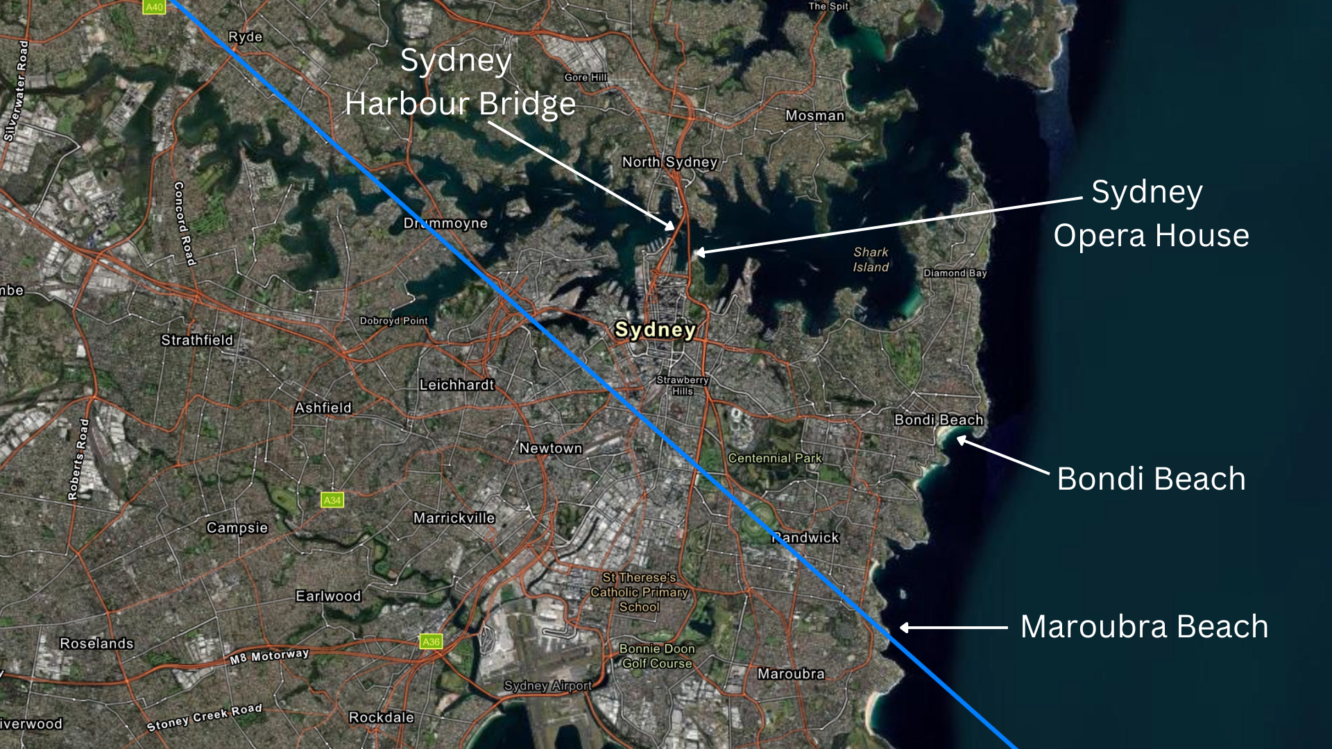
Sydney’s Opera House and Harbour Bridge will form a spectacular backdrop and grab the headlines before and after the event. However, eclipse chasers will likely head far to the northwest to the remote Kimberley region and the Australian Outback, where probable cloud-free winter skies promise over five minutes of totality. Meanwhile, New Zealand’s South Island will catch the final act of the eclipse close to sunset.
Related: What’s the difference between a total solar eclipse and an annular solar eclipse?
What’s special about the July 22, 2028, total solar eclipse?
This eclipse will feature a long totality over some iconic locations, including Sydney Harbour, as well as the Bungle Bungles and Karlu Karlu (Devil’s Marbles) in the Australian Outback. Sydney will attract the media attention and crowds, but the remote regions will have the highest chance of clear skies. Add Cocos Islands and Christmas Island, and there’s something for every kind of eclipse chaser, whether they’re looking to experience it with others or in lonelier surroundings.

For those bound for the Outback, there’s also the promise of dark skies and views of the Milky Way‘s core. There, Kununurra, Western Australia, and Alice Springs, Northern Territory, will be the logical bases. Get there a week before the eclipse if you want to make the best of dark skies, although the Delta Aquariid meteor shower peaks a week after the eclipse.
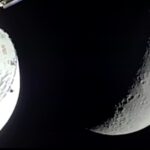
Path of totality for the total solar eclipse 2028
Image 1 of 5
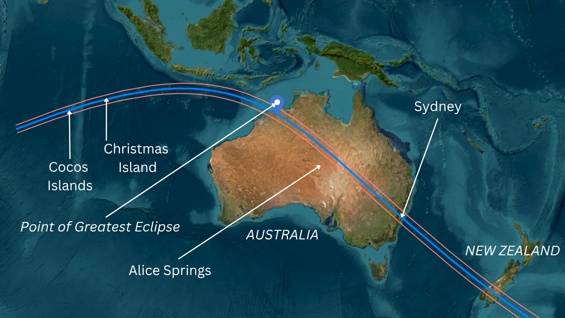
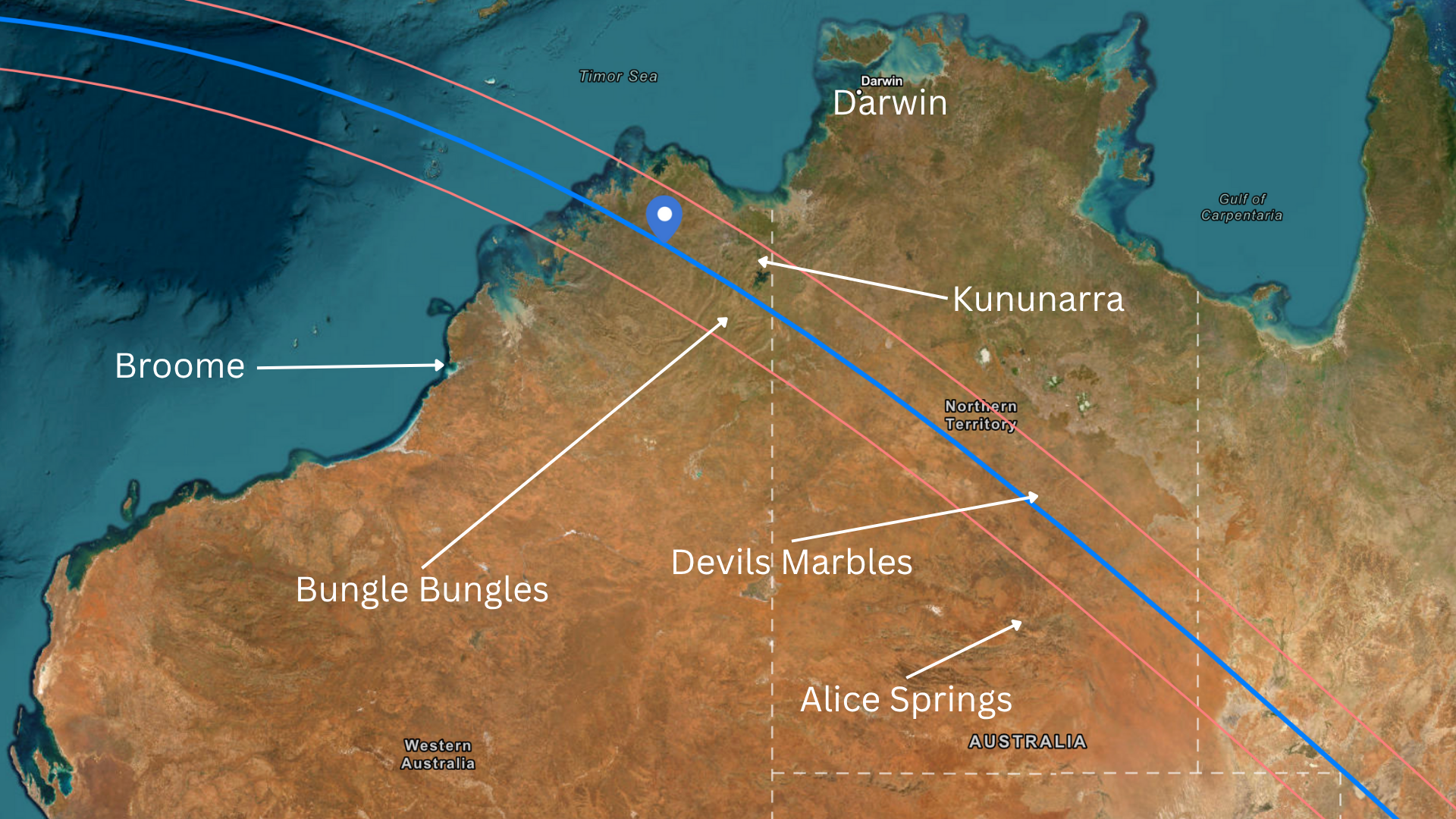
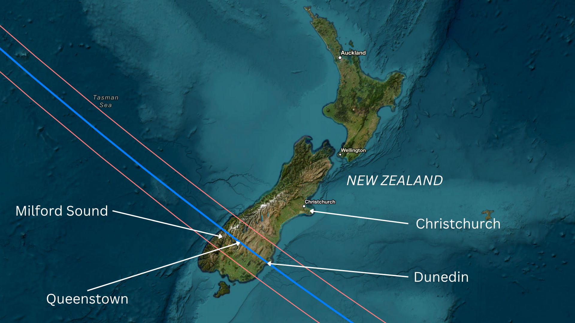
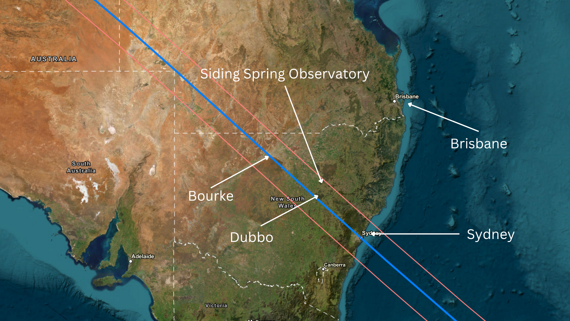
The eclipse path for the July 22, 2028, total solar eclipse spans 7,442 miles (11,976 km). The eclipse will begin at sunrise in the Indian Ocean; pass over the Cocos and Christmas islands; sweep across Western Australia, the Northern Territory, Queensland and New South Wales; and then finally cross the Tasman Sea to New Zealand.
The eclipse will last 2 hours, 49 minutes from first landfall to final contact, with a maximum totality of 5 minutes, 10 seconds occurring near the Drysdale River in Western Australia. About 6.3 million people live in the path of totality, according to Time and Date, with the vast majority residing in Sydney and its suburbs.

Where and when can I see the July 22, 2028 total solar eclipse?
|
Location |
Totality duration |
Time |
Sun height |
|---|---|---|---|
|
Direction Island, Cocos Islands |
3 minutes, 26 seconds |
8:12 a.m. CCT |
23.4 degrees northeast |
|
South Point, Christmas Island |
4 minutes, 5 seconds |
8:54 a.m. CXT |
34.3 degrees northeast |
|
Scott Reef, Indian Ocean |
4 minutes, 48 seconds |
9:37 a.m. AWST |
50.8 degrees northeast |
|
Lamarck Island, Australia |
5 minutes, 8 seconds |
10:47 a.m. AWST |
52.2 degrees northeast |
|
Wyndham, Australia |
3 minutes, 20 seconds |
10:57 a.m. AWST |
53.2 degrees northeast |
|
Bungle Bungles, Australia |
3 minutes, 18 seconds |
11:00 a.m. AWST |
51.5 degrees northeast |
|
Kununurra, Australia |
2 minutes, 50 seconds |
10:59 a.m. AWST |
53.2 degrees northeast |
|
Karlu Karlu, Australia |
4 minutes, 50 seconds |
12:48 p.m. ACST |
49.2 degrees northeast |
|
Siding Spring Observatory, Coonabarabran, Australia |
1 minute, 47 seconds |
1:56 p.m. AEST |
32.5 degrees northeast |
|
Dubbo, Australia |
3 minutes, 46 seconds |
1:55 p.m. AEST |
32 degrees northeast |
|
Sydney, Australia |
3 minutes, 44 seconds |
1:59 p.m. AEST |
29.1 degrees northeast |
What will the weather be like for the total solar eclipse?
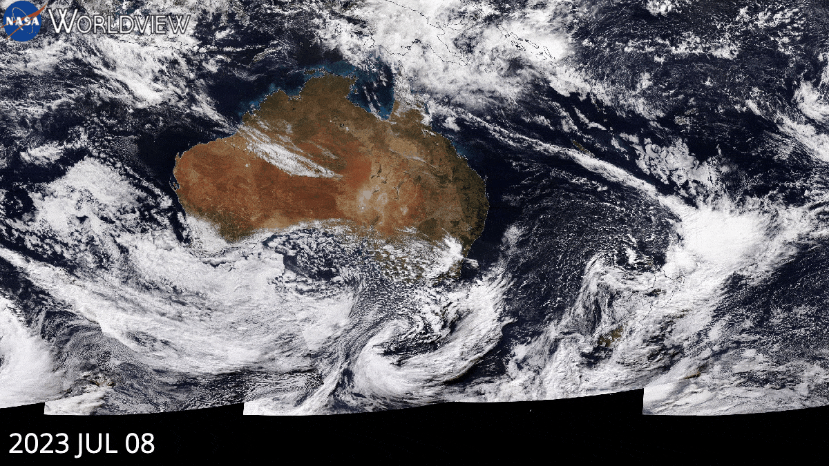
There’s a saying among eclipse chasers: “The climate is what you expect; the weather is what you get.” While you can maximize your chances of finding a clear sky if you’re mobile, you can also choose to visit the Outback, where clouds are less likely. According to Time and Date, Kununurra has had a cloudy day on July 22 about 11% of the time since 2000, compared with 10% for the Bungle Bungles and 23% for Karlu Karlu. Expect the one-lane roads in the Outback to be VERY busy.
The riskiest regions for clouds are, as usual, near the coast, with the highest chance of clouds being on Cocos Island (65%), Christmas Island (57%) and, annoyingly, Sydney (47%). This eclipse takes place in the Southern Hemisphere’s winter.
Where to see the partial solar eclipse on July 22, 2028
A partial solar eclipse will be visible across Australia, New Zealand and Southeast Asia on July 22, 2028.
|
Location |
Percentage of the sun’s disk covered |
|---|---|
|
Alice Springs, Australia |
95% |
|
Broome, Australia |
91% |
|
Jakarta, Indonesia |
89% |
|
Darwin, Australia |
88% |
|
Wellington, New Zealand |
83% |
|
Brisbane, Australia |
81% |
|
Melbourne, Australia |
81% |
|
Adelaide, Australia |
76% |
|
Hobart, Tasmania, Australia |
73% |
|
Singapore |
60% |
|
Kuala Lumpur, Malaysia |
52% |
|
Perth, Australia |
50% |
|
Ho Chi Minh City, Vietnam |
27% |
|
Phnom Penh, Cambodia |
24% |
|
Bangkok, Thailand |
16% |
|
Manila, Philippines |
13% |
After July 22, 2028, when is the next total solar eclipse?
After the total solar eclipse on July 22, 2028, these are the dates and locations for the next total solar eclipses:
- Nov. 25, 2030: Namibia, Botswana, South Africa, Lesotho and Australia
- Nov. 14, 2031: Pacific Ocean (totality) and Panama (annularity)
- March 30, 2033: Russia and the U.S. (Alaska)
- March 20, 2034: Benin, Nigeria, Cameroon, Chad, Sudan, Egypt, Saudi Arabia, Kuwait, Iran, Afghanistan, Pakistan, India and China
- Sept. 2, 2035: China, North Korea and Japan
- July 13, 2037: Australia
- Dec. 26, 2038: Australia and New Zealand
Additional resources
You can find a concise summary of solar eclipses out to 2030 on NASA’s eclipse website. Read more about solar and lunar eclipses on EclipseWise.com, a website dedicated to predictions of eclipses, and find beautiful maps on eclipse cartographer Michael Zeiler’s EclipseAtlas.com and interactive Google Maps on Xavier Jubier’s eclipse website and Timeanddate.com’s Eclipse Central hub. You can find climate and weather predictions by meteorologist Jay Anderson on Eclipsophile.com and advice on photography from expert eclipse photographer Alan Dyer at AmazingSky.com.
Bibliography
Bakich, M. and Zeiler, M. (2022). Atlas Of Solar Eclipses 2020-2045.
https://www.greatamericaneclipse.com/books/atlas-of-solar-eclipses-2020-to-2045
Jubier, X. (n.d.). Solar eclipses: Interactive Google Maps. Retrieved Jun. 24, 2025, from http://xjubier.free.fr/en/site_pages/SolarEclipsesGoogleMaps.html
NASA Worldview application, part of the NASA Earth Science Data and Information System (ESDIS). Retrieved Jun. 24, 2025 from https://worldview.earthdata.nasa.gov
Time and Date. (n.d.). July 22, 2028 Total Solar Eclipse. Retrieved Jun. 24, 2025, from https://www.timeanddate.com/eclipse/solar/2028-july-22


Related Posts

Stay Informed With the Latest & Most Important News
Previous Post
Next Post


Advertisement
-
 01Two Black Holes Observed Circling Each Other for the First Time
 -
 02From Polymerization-Enabled Folding and Assembly to Chemical Evolution: Key Processes for Emergence of Functional Polymers in the Origin of Life
 -
 03Astronomy 101: From the Sun and Moon to Wormholes and Warp Drive, Key Theories, Discoveries, and Facts about the Universe (The Adams 101 Series)
 -
 04True Anomaly hires former York Space executive as chief operating officer
 -
 05Φsat-2 begins science phase for AI Earth images
 -
 06Hurricane forecasters are losing 3 key satellites ahead of peak storm season − a meteorologist explains why it matters
 -
 07Binary star systems are complex astronomical objects − a new AI approach could pin down their properties quickly