
Now Reading: Vantor satellites track space objects in ‘blind spots’ inaccessible to military ground sensors
-
01
Vantor satellites track space objects in ‘blind spots’ inaccessible to military ground sensors

Vantor satellites track space objects in ‘blind spots’ inaccessible to military ground sensors
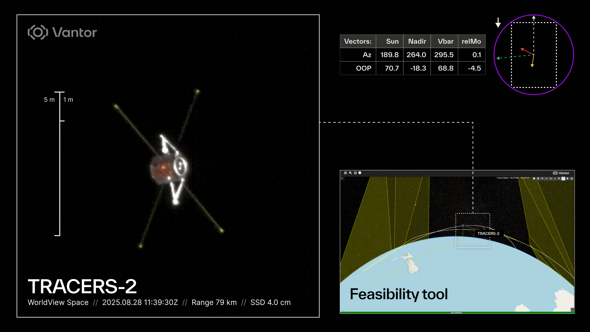

WASHINGTON — Vantor, the commercial Earth intelligence firm formerly known as Maxar Intelligence, has begun providing high-resolution space-to-space imagery to the U.S. Space Force, filling a gap in military surveillance of low Earth orbit, the company announced Oct. 22.
Under a contract with the Space Force’s Joint Commercial Operations (JCO) cell, located in Colorado, Vantor is delivering tracking data and imaging of satellites and other orbital objects that pass through “blind spots” in space that are not visible to ground sensor networks.
The contract details or financial value were not disclosed.
Vantor’s space-to-space intelligence business, also known as non-Earth imagery, is just three years old. It started following a December 2022 license modification by the National Oceanic and Atmospheric Administration (NOAA) that allowed Vantor to point its high-resolution satellites away from Earth and capture images of other spacecraft in orbit.
“Our ability to capture high resolution space-to-space images puts us in a strong position to help the Space Force safeguard U.S. assets,” said Susanne Hake, senior vice president and general manager of Vantor’s U.S. government business. “We’re not just providing pixels. We extract critical intelligence from this imagery, including spacecraft orientation, object velocity data — relative to Earth, to our satellite, to the sun — and deployment confirmation that telemetry alone can’t verify.”
Filling surveillance gaps
The company’s satellites can capture images of other spacecraft at resolutions finer than 10 centimeters from distances exceeding several hundred kilometers, said Hake.
The Space Force contract focuses on continuous tracking and positional updates for satellites of interest. This data is particularly valuable when orbital objects have the potential to change their trajectory — a scenario that could pose collision risks to U.S. military and government space assets or indicate potentially threatening behavior.
Hake noted that Vantor’s space observation capability does not require dedicated satellite time separate from the company’s core Earth observation business. “We’re both able to do all of our regular Earth observation at the same time when we’re over places where we don’t really need to look down,” she explained. The company conducts non-Earth imaging during passes over oceans and polar regions, areas where most Earth observation customers have limited interest.
While Vantor’s work with the Space Force highlights the military demand for space surveillance, Hake said commercial customers are also finding value in non-Earth imagery. Satellite operators, for instance, use these images to verify spacecraft deployment after launch — confirming that solar arrays or antennas have unfolded properly before telemetry data becomes available.
She said Vantor secured a separate contract with NOAA’s Office of Space Commerce to provide non-Earth imagery supporting space traffic management initiatives. This application addresses a coordination challenge when newly launched satellites possess limited or imprecise positional tracking data. During this critical window, collision risk spikes and coordination becomes difficult for satellite operators, launch providers and space traffic managers trying to maintain safe orbital operations.


Related Posts

Stay Informed With the Latest & Most Important News
Previous Post
Next Post


Advertisement
-
 01Two Black Holes Observed Circling Each Other for the First Time
 -
 02From Polymerization-Enabled Folding and Assembly to Chemical Evolution: Key Processes for Emergence of Functional Polymers in the Origin of Life
 -
 03Astronomy 101: From the Sun and Moon to Wormholes and Warp Drive, Key Theories, Discoveries, and Facts about the Universe (The Adams 101 Series)
 -
 04True Anomaly hires former York Space executive as chief operating officer
 -
 05Φsat-2 begins science phase for AI Earth images
 -
 06Hurricane forecasters are losing 3 key satellites ahead of peak storm season − a meteorologist explains why it matters
 -
 07Binary star systems are complex astronomical objects − a new AI approach could pin down their properties quickly