
Now Reading: Vantor wins $5.3 million NGA contract to spot terrain changes using commercial satellite data
-
01
Vantor wins $5.3 million NGA contract to spot terrain changes using commercial satellite data

Vantor wins $5.3 million NGA contract to spot terrain changes using commercial satellite data
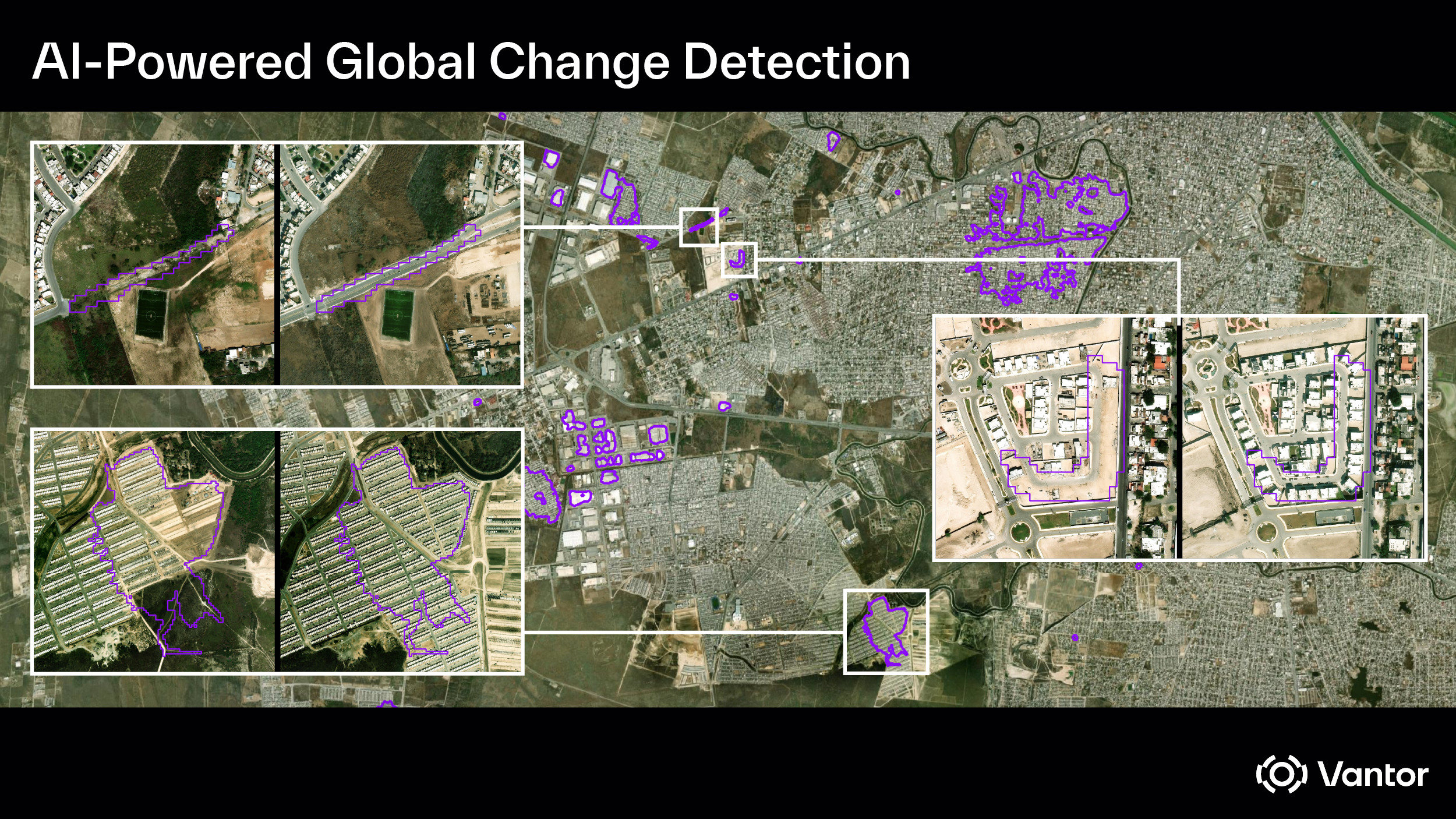

WASHINGTON — Vantor, a commercial Earth observation satellite operator, said Feb. 5 it won a $5.3 million contract from the National Geospatial-Intelligence Agency to detect and deliver automated insights on real-time changes to the Earth’s landscape.
Based in Westminster, Colorado, Vantor, formerly known as Maxar Intelligence, operates a constellation of high-resolution imaging satellites and works with partner firms to integrate other data sources, including synthetic aperture radar imagery, with its own electro-optical images.
Under the contract, Vantor will combine data from its own satellites with third-party electro-optical and synthetic aperture radar systems to identify changes to physical terrain on the ground, including shifts in infrastructure and land use.
The award was made under NGA’s Luno program, an effort by the agency to draw on unclassified commercial geospatial intelligence, machine learning and artificial intelligence to support U.S. government analysis. The program is divided into two indefinite delivery, indefinite quantity contract vehicles, known as Luno A and Luno B. Vantor’s latest award was made under Luno B. The company won a task order last year under Luno A.
Luno A is a roughly $290 million, five-year contract focused on commercial computer vision and analytic services, with 10 companies selected to compete for delivery orders. Luno B is a $200 million, five-year contract designed to give the national security community broad access to commercial geospatial intelligence data and related analytic services. Thirteen companies were selected for Luno B.
NGA seeks automated change detection
“Detecting different types of change is important for NGA for a lot of their mapping and intelligence missions, whether it’s for natural and man-made disasters, regional conflicts and events that require humanitarian assistance,” said Susanne Hake, Vantor’s executive vice president and general manager for U.S. government business.
For this Luno B task order, she said, “we’re using a lot of different types of sensors. We’re running advanced AI algorithms over the data and identifying changes to the Earth’s terrain, and in particular, looking at changes on roads, buildings, vegetation and different types of land cover elements.”
Hake said combining data from multiple sensors presents technical challenges because each system captures the Earth differently, with varying resolutions, viewing angles and spatial accuracy. If those differences are not corrected first, she said, automated change detection models can fail, since they depend on precise, pixel-level alignment to determine what has changed on the ground.


Related Posts


Stay Informed With the Latest & Most Important News
Previous Post
Next Post
Previous Post
Next Post


Advertisement
-
 01Two Black Holes Observed Circling Each Other for the First Time
 -
 02From Polymerization-Enabled Folding and Assembly to Chemical Evolution: Key Processes for Emergence of Functional Polymers in the Origin of Life
 -
 03Astronomy 101: From the Sun and Moon to Wormholes and Warp Drive, Key Theories, Discoveries, and Facts about the Universe (The Adams 101 Series)
 -
 04True Anomaly hires former York Space executive as chief operating officer
 -
 05Φsat-2 begins science phase for AI Earth images
 -
 06Hurricane forecasters are losing 3 key satellites ahead of peak storm season − a meteorologist explains why it matters
 -
 07Binary star systems are complex astronomical objects − a new AI approach could pin down their properties quickly