
Now Reading: Vega-C Rocket Launches New Satellites for Earth Observation and Climate Monitoring
-
01
Vega-C Rocket Launches New Satellites for Earth Observation and Climate Monitoring

Vega-C Rocket Launches New Satellites for Earth Observation and Climate Monitoring


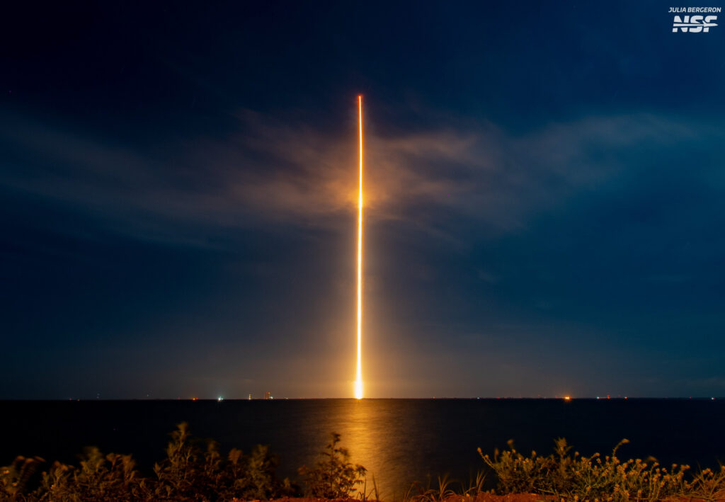
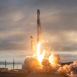
On the evening of July 25, 2023, the world watched as the Vega-C rocket, poised at Europe’s Spaceport in Kourou, French Guiana, roared to life at precisely 23:03 local time. This moment marked the successful liftoff of VV27, a mission that encapsulated the spirit of innovation and cooperation within the international space community.
The launch vehicle, Vega-C, represents an evolution in the Vega rocket family, showcasing enhancements in both payload capacity and operational versatility. This particular flight was operated by Arianespace, a leader in the global launch services market. With its streamlined design and cutting-edge tech, Vega-C is crafted to efficiently deliver a wide array of satellites into low Earth orbit (LEO), catering to various scientific, commercial, and governmental missions.
As the fiery plume of the launch illuminated the night sky, anticipation filled the air. The successful deployment of the payload – the four CO3D satellites and the MicroCarb mission – was meticulously executed, demonstrating the robust capabilities of the Vega-C platform. Each satellite plays a vital role in driving our understanding of the planet, highlighting how these missions contribute to our global knowledge.
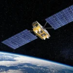
The CO3D constellation, an acronym deriving from ‘Constellation Optique en 3D’, consists of four small satellites designed to map the Earth in stunning three-dimensional detail. This imagery will not only support scientific research but also empower various sectors, including agriculture, urban planning, and disaster management. By providing high-resolution data, the CO3D satellites are set to revolutionize how we visualize and interact with our planet.
Meanwhile, the MicroCarb mission stands at the forefront of climate science. Engineered to monitor carbon dioxide levels from space, MicroCarb aims to provide pivotal data for understanding carbon sources and sinks. This information especially important in the fight against climate change, allowing researchers and policymakers to track emissions and develop strategies for mitigation. The European Space Agency (ESA), acting on behalf of the European Commission, coordinated and procured this humanitarian mission as part of its In-Orbit Demonstration/In-Orbit Validation (IOD/IOV) programme, underscoring Europe’s commitment to addressing pressing global challenges.
In essence, VV27 not only exemplifies technical prowess and precision in aerospace engineering but also serves as a testament to the collaborative spirit of nations working together to unlock the mysteries of our planet. The successful launch from French Guiana is more than just a step in space exploration; it’s a leap towards a better understanding of Earth itself, enabling humanity to make informed decisions about our environment.
Each of the satellites deployed during the VV27 mission plays a distinct and critical role in enhancing our understanding of Earth and its systems. The CO3D constellation operates with a unique synergy that allows for comprehensive data collection, generating insights that support a variety of industries and scientific research. These satellites are equipped with advanced optical imagery capabilities that will enable them to capture high-resolution, three-dimensional maps of the Earth’s surface. Such detailed imaging is invaluable in applications ranging from urban development to environmental monitoring, particularly in regions that require timely and accurate geographical data.
For instance, urban planners can use the data from the CO3D satellites to simulate infrastructure and land-use scenarios, enhancing their decision-making processes. In agriculture, farmers could benefit from precise topography and crop health data, enabling them to optimize yields while minimizing resource waste. The versatility of CO3D’s five-band optical sensor captures different wavelengths, which opens doors to innovative applications in climate monitoring and disaster response. This level of detail not only empowers professionals across sectors but also inspires a new generation of scientists and engineers to push the boundaries of what is possible.
On the other hand, the MicroCarb mission signifies a monumental stride in our ability to monitor greenhouse gases, particularly carbon dioxide. This satellite utilizes cutting-edge imaging spectrometry technology to detect CO2 concentrations with unprecedented precision. By mapping these emissions globally, MicroCarb helps identify natural carbon sinks, such as forests and oceans, and human-made sources, including urban areas and industrial sites. The data produced is expected to support international climate agreements such as the Paris Accord, providing policymakers with the necessary insights to craft effective environmental policies and strategies.
Data collated from both the CO3D and MicroCarb satellites will feed into a larger ecosystem of information that includes ground-based observations and models, leading to even more refined climate and environmental forecasting. This holistic approach is critical as we face the multifaceted challenges of climate change, biodiversity loss, and urban development. The insights garnered from these missions promise to elevate our collective understanding and capacity to act.
The collaborative nature of this mission is another aspect that cannot be overstated. The partnership between Arianespace, Airbus, and the European Space Agency exemplifies how shared expertise and resources can yield powerful tools for global progress. With the seamless integration of technology and science, the contributions from national and international partners signify a concerted effort to tackle complex problems facing humanity. Each stakeholder brings specialized knowledge to the table, creating a rich tapestry of innovation.
The VV27 mission is not merely the launch of satellites; it’s the ignition of new capabilities to observe, analyze, and ultimately understand our planet better. As humanity looks to the stars, these satellites will keep our feet firmly planted on the ground, providing clarity in the midst of uncertainty. From urban planners to environmental scientists, the reach of the data generated will be felt across a high number of disciplines, marking a significant milestone in our endeavors to create a sustainable future.


Related Posts

Stay Informed With the Latest & Most Important News
Previous Post
Next Post
Advertisement
-
 01Two Black Holes Observed Circling Each Other for the First Time
 -
 02From Polymerization-Enabled Folding and Assembly to Chemical Evolution: Key Processes for Emergence of Functional Polymers in the Origin of Life
 -
 03Astronomy 101: From the Sun and Moon to Wormholes and Warp Drive, Key Theories, Discoveries, and Facts about the Universe (The Adams 101 Series)
 -
 04True Anomaly hires former York Space executive as chief operating officer
 -
 05Φsat-2 begins science phase for AI Earth images
 -
 06Hurricane forecasters are losing 3 key satellites ahead of peak storm season − a meteorologist explains why it matters
 -
 07Binary star systems are complex astronomical objects − a new AI approach could pin down their properties quickly