
Now Reading: Where the ridge meets the river | Space photo of the day for Oct. 16, 2025
-
01
Where the ridge meets the river | Space photo of the day for Oct. 16, 2025

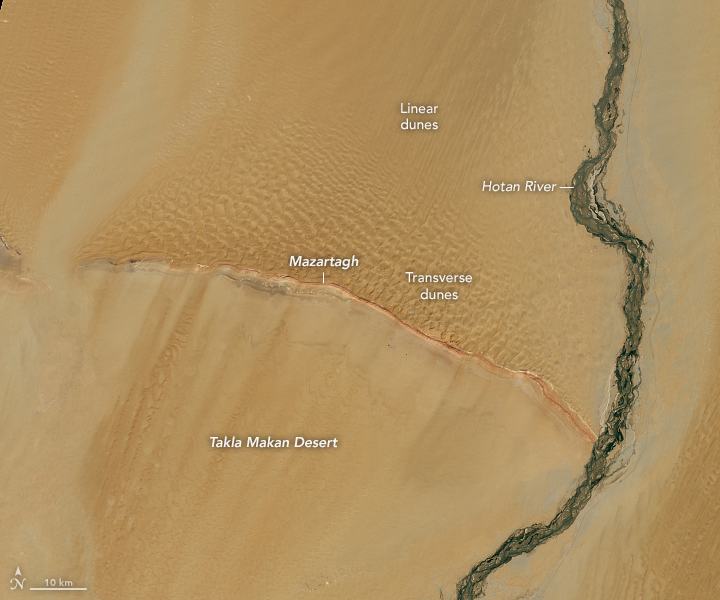
Seen from space, western China’s Tarim Basin shows the importance of waterways. The image, taken by the OLI-2 (Operational Land Imager-2) instrument on the Landsat-9 satellite, captures the geological and environmental crossroads where desert winds and glacial meltwater converge.
What is it?
Launched in 2021 as part of a long legacy of Earth-observing satellites, Landsat 9 is a joint mission of NASA and the U.S. Geological Survey (USGS). The satellite is equipped with state-of-the-art sensors. It captures high-resolution images in both visible and infrared light, allowing scientists to track environmental changes across continents, from shrinking glaciers and shifting coastlines to urban expansion and desert dynamics.
In this image, Landsat 9 reveals the Mazartagh Ridge rising around 600 feet (180 meters) above the surrounding sands, acting as a natural barrier against the relentless winds that sweep China’s Takla Makan Desert.
Where is it?
This photograph was taken from 438 miles (705 km) above Earth in Landsat 9’s orbit.

Why is it amazing?
The Hotan River, a dark green thread flowing from north to south in this image, carries glacial meltwater deep into the desert until it merges with the Tarim River.
Despite flowing through one of the world’s most arid regions, the Hotan feeds ribbons of vegetation sprouting around its banks. Beyond its ability to sustain life, the Hotan’s sediments once contained nephrite jade in both white and green varieties, making the region a key stop along the historic Silk Road, where traders once exchanged jade, silk and stories of far-off lands.
Want to learn more?
You can learn more about waterways and images of Earth from space.


Related Posts


Stay Informed With the Latest & Most Important News
Previous Post
Next Post


Advertisement
-
 01Two Black Holes Observed Circling Each Other for the First Time
 -
 02From Polymerization-Enabled Folding and Assembly to Chemical Evolution: Key Processes for Emergence of Functional Polymers in the Origin of Life
 -
 03Astronomy 101: From the Sun and Moon to Wormholes and Warp Drive, Key Theories, Discoveries, and Facts about the Universe (The Adams 101 Series)
 -
 04True Anomaly hires former York Space executive as chief operating officer
 -
 05Φsat-2 begins science phase for AI Earth images
 -
 06Hurricane forecasters are losing 3 key satellites ahead of peak storm season − a meteorologist explains why it matters
 -
 07Binary star systems are complex astronomical objects − a new AI approach could pin down their properties quickly