
Now Reading: Strait of Hormuz crisis drives demand for commercial geospatial intelligence
-
01
Strait of Hormuz crisis drives demand for commercial geospatial intelligence


WASHINGTON — The conflict between the United States and Iran is turning the Strait of Hormuz into a live testing ground for commercial geospatial intelligence — a role similar to what the Ukraine war played for satellite imagery providers.
The narrow waterway linking the Persian Gulf to the Gulf of Oman carries roughly one-fifth of the world’s seaborne oil trade, making it one of the most strategically important shipping chokepoints in the global energy system. After the United States and Israel launched strikes against Iran on Feb. 28, Tehran effectively shut down most commercial traffic through the strait as mines and the threat of missile strikes has made transit too risky for shipping companies.
The result is a suddenly urgent demand for real-time visibility into what is happening on the water.
“This is a dynamic situation where maritime traffic patterns are shifting within hours of an incident,” said Jesse Kallman, chief executive of Danti, an Atlanta-based company that builds artificial intelligence tools for searching Earth observation data.
The normally busy shipping corridor has become a contested maritime environment where governments, energy companies, insurers and militaries are trying to understand events as they unfold.
Kallman said the crisis is driving demand for tools that combine satellite imagery with other sources of intelligence.
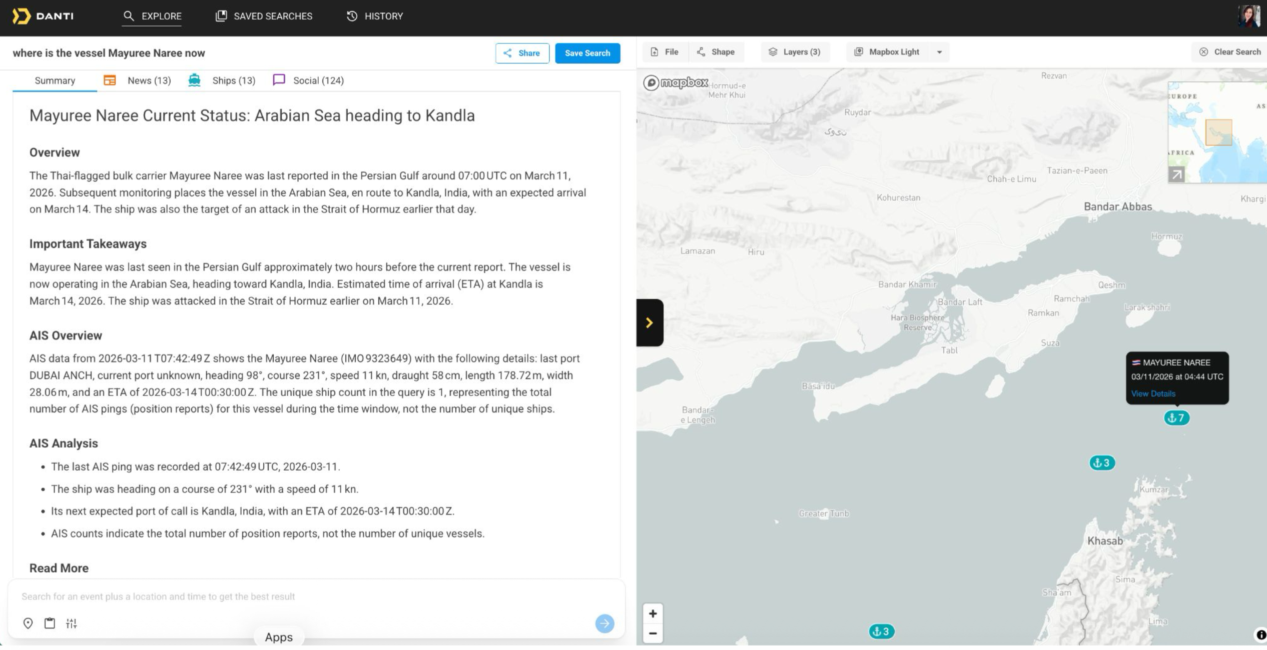
Danti’s platform allows users to track vessel activity in the strait using open-source intelligence that includes satellite and drone imagery, social media feeds and shipping data. Users can type questions into the system — such as “what ships are under attack in the Strait of Hormuz?” — and receive an aggregated picture of the situation.
The company’s technology does not depend on new sensors or scientific breakthroughs. It applies AI models to organize and interpret existing data streams widely used in geospatial intelligence. The system aggregates satellite and drone imagery, radio-frequency and other signals data, automatic identification system (AIS) ship tracking feeds, social media posts and other open-source information, allowing users to query the combined dataset in natural language.
What the system can see, however, depends largely on what data customers already have access to. Defense and intelligence agencies often subscribe to multiple commercial satellite operators and may have access to classified or proprietary sensor feeds, while commercial organizations typically rely on a smaller set of imagery providers and open data.
“An analyst who’s not an expert in maritime domain awareness can execute complex patterns-of-life analysis and see things happen before it hits the news,” Kallman said.
Multiple sources fill gaps
The situation in the strait highlights the limits of relying on satellite imagery alone. Images provide detailed views of vessels, ports and infrastructure, but they are essentially snapshots taken when a satellite passes overhead. Even with large commercial constellations, a location may only be imaged every few hours.
In a contested maritime corridor where vessels can change course in minutes, those gaps matter. An image might show a tanker at a particular position at a given time, but it cannot reveal where the vessel went moments later or whether it suddenly altered course.
Other data sources fill those gaps. AIS transponders broadcast ship positions continuously, while social media posts, port notices and other open-source reporting can reveal incidents almost immediately. AI systems increasingly combine those streams to build a continuous operational picture.
Kallman said the crisis has pushed the demands of maritime domain awareness to “a different scale.” Meanwhile, “the amount of open-source information coming into defense and intelligence is growing at an exponential rate.” He added that open-source intelligence — once used mainly as a supplement to government systems — is increasingly becoming a primary source of operational insight.
Filtering that flood of information is its own challenge, especially as AI-generated or misleading posts proliferate online. Danti attempts to limit those risks by ranking information sources according to credibility.
The platform assigns reliability scores based on factors such as past accuracy, institutional affiliation and whether claims align with other data streams. Information from trusted outlets and accounts is elevated while unverified posts are suppressed, helping analysts avoid amplifying false reporting.


Related Posts

Stay Informed With the Latest & Most Important News
Previous Post
Next Post


Advertisement
-
 01Two Black Holes Observed Circling Each Other for the First Time
 -
 02From Polymerization-Enabled Folding and Assembly to Chemical Evolution: Key Processes for Emergence of Functional Polymers in the Origin of Life
 -
 03Astronomy 101: From the Sun and Moon to Wormholes and Warp Drive, Key Theories, Discoveries, and Facts about the Universe (The Adams 101 Series)
 -
 04True Anomaly hires former York Space executive as chief operating officer
 -
 05Φsat-2 begins science phase for AI Earth images
 -
 06Hurricane forecasters are losing 3 key satellites ahead of peak storm season − a meteorologist explains why it matters
 -
 07Binary star systems are complex astronomical objects − a new AI approach could pin down their properties quickly