
Now Reading: Stunning Satellite Imagery Reveals Kimberley’s King Sound and Its Vital Ecosystems
-
01
Stunning Satellite Imagery Reveals Kimberley’s King Sound and Its Vital Ecosystems

Stunning Satellite Imagery Reveals Kimberley’s King Sound and Its Vital Ecosystems
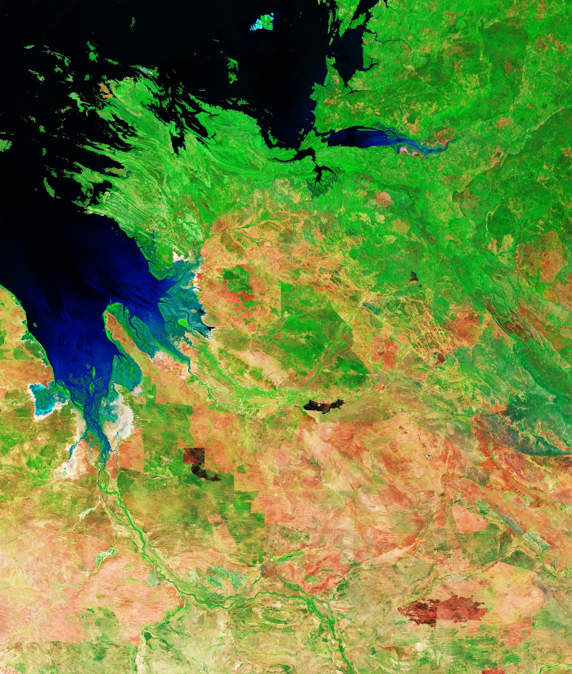

The Kimberley region of Western Australia has received renewed attention thanks to striking observations captured by the Copernicus Sentinel-2 mission. The imagery showcases a stunning panoramic view of the coastline along the Indian Ocean, highlighting the King Sound inlet—a remarkable gulf stretching about 120 kilometers in length and 50 kilometers in width. Known for experiencing Australia’s highest tides, King Sound boasts a tidal range that can reach between 11 to 12 meters, making it one of the top tide locations worldwide. This impressive body of water receives contributions from several rivers, including the Fitzroy River, one of the country’s most significant waterways, which flows into the gulf.
Acquired in December 2025, the latest images present dual perspectives using diverse spectral band combinations from the Sentinel-2 satellite. The first view, showcasing natural colors, portrays a scene akin to what the human eye would perceive, while the second view employs a false-color technique that accentuates distinct geographic features. In the natural-color image, expansive mud flats obscure a network of mangrove estuaries that thrive along the shore. However, the false-color rendition highlights these crucial ecosystems in vibrant neon green, underscoring their density and importance in maintaining the health of coastal and estuarine environments while offering protection against coastal erosion.
The river discharge laden with sediment imparts a brownish tint to King Sound’s waters in the natural-color image, suggesting shallower depths. In contrast, the false-color visualization presents the water in dark blue and black shades, indicating areas of deeper water with higher sediment concentrations at the surface. Beyond the coast, the hinterland transitions from lush grasslands to the arid deserts that characterize much of Australia’s interior. Dominated by sparse green vegetation interspersed with deep hues of ochre and rusty red, the landscape reveals pindan soil, a nutrient-rich medium abundant in iron oxides typically found in the southwestern regions of Kimberley.
While the natural-color image can obscure the visibility of fire damage on the terrain, the false-color representation makes such burn scars distinctly apparent. This enhanced visibility of wildfire-affected areas provides valuable insights for monitoring fire occurrence, mapping burned regions, and assessing environmental impacts in this fire-prone region, thereby assisting local authorities and researchers in their efforts to manage the land and its ecosystems effectively.


Related Posts


Stay Informed With the Latest & Most Important News


Advertisement
-
 01Two Black Holes Observed Circling Each Other for the First Time
 -
 02From Polymerization-Enabled Folding and Assembly to Chemical Evolution: Key Processes for Emergence of Functional Polymers in the Origin of Life
 -
 03Astronomy 101: From the Sun and Moon to Wormholes and Warp Drive, Key Theories, Discoveries, and Facts about the Universe (The Adams 101 Series)
 -
 04True Anomaly hires former York Space executive as chief operating officer
 -
 05Φsat-2 begins science phase for AI Earth images
 -
 06Hurricane forecasters are losing 3 key satellites ahead of peak storm season − a meteorologist explains why it matters
 -
 07Binary star systems are complex astronomical objects − a new AI approach could pin down their properties quickly