
Now Reading: ESA Launches Arctic Mission to improve Satellite Monitoring of Sea Ice Amid Climate Change
-
01
ESA Launches Arctic Mission to improve Satellite Monitoring of Sea Ice Amid Climate Change

ESA Launches Arctic Mission to improve Satellite Monitoring of Sea Ice Amid Climate Change

As the impacts of climate change become increasingly evident, precise monitoring of sea ice is essential. In response to this pressing need, the European Space Agency (ESA) is advancing the development of three innovative Copernicus satellites, each using unique yet synergistic methods to observe this critical element of our planet’s ecology. The initiative aims to create highly accurate datasets, with an international cohort of scientists venturing into the Arctic to gather crucial on-the-ground measurements amid the harsh conditions.
This initiative, known as the Copernicus Expansion Missions Sea Ice Experiment, focuses on three specific satellites: the Copernicus Imaging Microwave Radiometer (CIMR), the Copernicus Polar Ice and Snow Topography Altimeter (CRISTAL), and the Copernicus Radar Observing System for Europe at L-band (ROSE-L). These missions form part of six new Copernicus Sentinel Expansion missions that the ESA is preparing as part of the European Union’s Earth observation program. With a diverse range of observational capabilities, these new satellites aim to fill existing gaps within the Copernicus framework and align with EU policy goals.
The development of these sophisticated satellites necessitates more than theoretical studies or laboratory experiments; it also requires extensive field research where scientists and engineers evaluate satellite instruments in real-world conditions. Such field campaigns are vital for validating measurement techniques, enhancing instrument performance, and optimizing data retrieval algorithms. These efforts serve as an important link between the design of new measuring tools and their successful operation in orbit, even when building upon established technologies.
To ensure the accuracy of the CIMR, CRISTAL, and ROSE-L missions—each targeting varying aspects of sea ice properties and other environmental factors—scientists are undertaking simultaneous field and airborne observations. The challenge of accurately measuring critical parameters such as snow depth, salinity, and ice thickness is heightened in polar regions, where changes occur rapidly due to climate fluctuations.
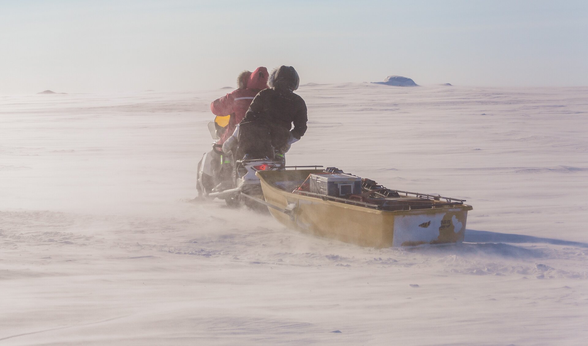
Currently, teams from a high number of institutions, including the University of Calgary and NASA, are conducting a six-week field campaign based in Cambridge Bay, Nunavut, in Canada’s Arctic. By gathering essential data from both the ice and the sky, they hope to refine the retrieval methods for the upcoming missions, ensuring that they provide reliable and precise observations of the polar environment.
This Arctic expedition is no small feat. Scientists are enduring extreme conditions as they set up their instruments on the sea ice—all while contending with freezing temperatures and strong winds. The campaign involves both ground-based measurements and aerial surveys, with helicopters facilitating transport to more isolated study sites. The teams are also attempting to coordinate their efforts with existing satellite missions, flying below ESA’s CryoSat, Sentinel-3, and NASA’s ICESat, to improve data collection.
ESA Campaign Scientist Tania Casal emphasized the complexity of this campaign, which draws inspiration from the successful Multidisciplinary drifting Observatory for the Study of Arctic Climate (MOSAiC) experiment and adapts its framework for new objectives. The focus is on first-year sea ice, specifically conditions that allow saline layers to persist below the snow cover—a phenomenon that significantly affects microwave scattering properties and satellite data retrieval.
Unlike the MOSAiC expedition, which drifted with the ice, this campaign is concentrated in a stable environment to guarantee consistent measurements unaffected by ice movement. Cambridge Bay is identified as an ideal location for these operations, offering convenient access to representative first-year ice conditions necessary for valid experimental setups.
The extensive data being collected includes a variety of ground observations and airborne data from laser and radar technology, which collectively inform on critical aspects like snow depth, ice thickness, and surface characteristics. By synchronizing these diverse datasets with satellite observations, the team aims to enhance the performance of CIMR, CRISTAL, and ROSE-L before their launch, thereby minimizing uncertainties and bolstering confidence in the data provided post-launch.


Related Posts

Stay Informed With the Latest & Most Important News


Advertisement
-
 01Two Black Holes Observed Circling Each Other for the First Time
 -
 02From Polymerization-Enabled Folding and Assembly to Chemical Evolution: Key Processes for Emergence of Functional Polymers in the Origin of Life
 -
 03Astronomy 101: From the Sun and Moon to Wormholes and Warp Drive, Key Theories, Discoveries, and Facts about the Universe (The Adams 101 Series)
 -
 04True Anomaly hires former York Space executive as chief operating officer
 -
 05Φsat-2 begins science phase for AI Earth images
 -
 06Hurricane forecasters are losing 3 key satellites ahead of peak storm season − a meteorologist explains why it matters
 -
 07Binary star systems are complex astronomical objects − a new AI approach could pin down their properties quickly