
Now Reading: Drone Radar Reveals Buried Glaciers On Earth, Guiding The Search For Water On Mars
-
01
Drone Radar Reveals Buried Glaciers On Earth, Guiding The Search For Water On Mars

Drone Radar Reveals Buried Glaciers On Earth, Guiding The Search For Water On Mars

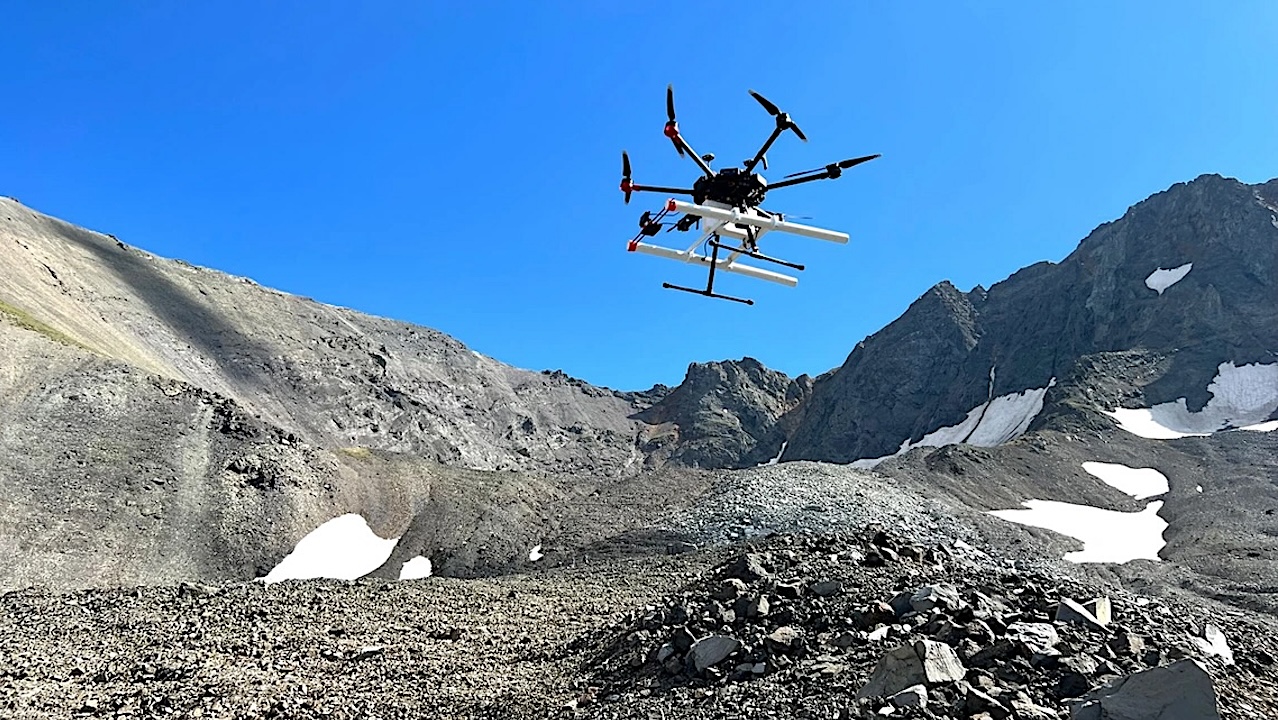
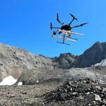
Silhouetted against the blue sky, a drone carrying a ground-penetrating radar instrument lifts off from Galena Creek Rock Glacier in Wyoming. — Jack W. Holt
Understanding how to explore hidden glaciers on Mars begins not in a laboratory, but in remote field camps across Alaska and Wyoming.
Armed with mosquito repellent, bear spray and drone batteries charged by a generator the night before, a team of researchers at the University of Arizona spent long days driving off-road, hiking rugged terrain and launching drones.
In a study published in the Journal of Geophysical Research: Planets, the team demonstrated that ground-penetrating radar mounted on drones can map the thickness of rocky debris covering glaciers on Earth. These results could help future astronauts locate accessible water locked in buried ice on the Red Planet.
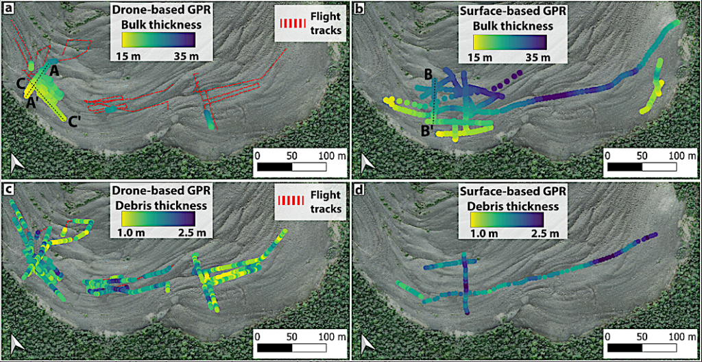
Bulk thickness and supraglacial debris thickness in the lower section of Sourdough Rock Glacier. (a) Bulk thickness retrieved from DGPR, surveyed in 2022. (b) Bulk thickness retrieved from surface-based ground-penetrating radar (GPR) centered at 50 and 100 MHz, surveyed in 2019 and 2021. Bulk thickness values in panels a and b were depth-corrected with an electromagnetic wave speed of 0.149 m/ns (ϵ’ = 4). (c) Supraglacial debris thickness retrieved from DGPR, surveyed in 2022. (d) Supraglacial debris thickness retrieved from surface-based GPR centered at 100 and 200 MHz, surveyed in 2018 and 2019. Debris thickness values in panels c and d were depth-corrected with an electromagnetic wave speed of 0.1 m/ns (ϵ’ = 9). — JGR Planets
“If you want to make decisions about where to drill on Mars, you need to know if the ice you’re trying to find is under one meter of debris or 10,” said Roberto Aguilar, a doctoral researcher at the University of Arizona Lunar and Planetary Laboratory and first author of the paper. “That’s the kind of information a drone-based system could provide.”
Most people picture glaciers as massive blocks of exposed ice, dusted with bright white, powdery snow. Debris-covered glaciers, however, appear very different, with their icy core hidden by thick layers of rock and sediment. These glaciers are found in mountainous regions on Earth, including warmer areas such as Colorado and California, where debris helps insulate and keep the ice underneath from melting.
On Mars, debris-covered glaciers are found in mid-latitude regions, halfway between the equator and the polar caps. According to Aguilar, some Martian ice deposits occur in craters that have been filled with ice and later covered by dust. Others form in large valleys where ice accumulated and was subsequently buried by debris. In mountainous regions, rockfall can also act as a protective layer, shielding the underlying ice from escaping into the atmosphere.
“Some of these deposits are large enough that radars on orbiting spacecraft can detect and estimate the amount of ice, but current technology cannot determine fine details, such as how thick the overlying debris layer is, or if there are internal, rocky layers hidden from view,” Aguilar said.
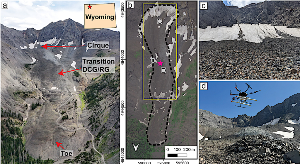
Galena Creek rock glacier (RG), Wyoming. (a) Oblique image acquired in August 2024, highlighting the cirque and the transition from an ice-cored debris-covered glacier to an ice-cemented RG in the steepest section of the glacier, and the glacier toe. (b) Satellite image acquired in 2022, map projected to WGS 84/UTM Zone 12N. Magenta Star is the location of the weather station. The yellow box inset is the map shown in Figures 8 and 10. (c) The headwall, as observed from the cirque, marked as C in panel b. (d) DGPR operations at Galena Creek, marked as D in panel b. — JGR Planets
The researchers believe drone radar could solve the problem by scouting out glacier ice and mapping rocky debris on top of it. Instead of drilling blindly through layers of rock and dust, mission planners could target sites where ice lies closest to the surface.
According to Aguilar, buried ice could be one of Mars’ most valuable resources. Water ice on Mars could preserve a record of past environmental conditions, support future astronauts through drinking water supplies, oxygen production and agriculture, and help guide drilling for astrobiology research.
To get there, however, the team first needed to test the approach on Earth.
“We already knew ground-penetrating radar works, but this was the first time we mounted it to drones and tested how we could put it into practice,” said Aguilar. “For instance, we learned at what altitude and speed the drone should fly, as well as the importance of flying in the direction of the glacier’s flow, and how to make sure the radar was properly aligned to detect the ice.”
The team focused on sites in Alaska and Wyoming, where years of research had already provided clues about glacier thickness and composition.
“These debris-covered glaciers on Earth are some of the best analogs we have for similar glaciers that spacecraft have photographed on Mars,” Aguilar said. “While this ground-penetrating radar doesn’t work in every terrain, we found the technology could be applied to planetary exploration, including identifying potential drilling sites on Mars.”
The team compared measurements obtained with radar to those from excavating and drilling into the glaciers. The measurements of debris thickness matched, validating their method as reliable and effective.
Because drones can fly much closer to the surface than orbiting spacecraft, they can image the ground at much higher resolution. This allowed the researchers to not only estimate debris thickness but also assess the purity of the ice and spot any rocky layers hidden inside.
“The internal layers we’re seeing are important because they’re a record of past climate cycles,” Aguilar said. “Each layer represents a different period of ice accumulation and environmental conditions over centuries or millennia, and it is likely we would see similar layers on Mars.”
The team also used simulations to make sure that the radar wasn’t being fooled by nearby trees or boulders. They were able to confirm that the signals were coming from below the rubble.
“We are filling the gap between today’s orbital observations and a more distant future, where astronauts land on Mars and make observations on the ground,” said Aguilar. “This gives us a way to investigate the glaciers now, from the air.”
Testing that future technology was rarely glamorous. In Alaska, it meant carrying gear through mosquito swarms and rough terrain. In Wyoming, the field season often meant hauling equipment deeper into the mountains. Some days, the team hiked across boulder fields to reach specific targets higher on the glacier.
“It’s not fun walking on those rocks,” Aguilar said. “That’s why it’s better to fly a drone.”
Revealing the Internal Structure of Mars-Analog Glaciers From Drone-Based Radar Sounding, JGR Planets (open access)
Astrobiology, Astrogeology,


Related Posts

Stay Informed With the Latest & Most Important News

Advertisement
-
 01Two Black Holes Observed Circling Each Other for the First Time
 -
 02From Polymerization-Enabled Folding and Assembly to Chemical Evolution: Key Processes for Emergence of Functional Polymers in the Origin of Life
 -
 03Astronomy 101: From the Sun and Moon to Wormholes and Warp Drive, Key Theories, Discoveries, and Facts about the Universe (The Adams 101 Series)
 -
 04True Anomaly hires former York Space executive as chief operating officer
 -
 05Φsat-2 begins science phase for AI Earth images
 -
 06Hurricane forecasters are losing 3 key satellites ahead of peak storm season − a meteorologist explains why it matters
 -
 07Binary star systems are complex astronomical objects − a new AI approach could pin down their properties quickly