
Now Reading: A Full Moon Checkup
-
01
A Full Moon Checkup

In April 2026, NASA’s Artemis program took humanity back to the Moon, providing a new look at Earth’s only natural satellite. As the world celebrates the return of Artemis II’s four astronauts, the lunar surface continues to play a critical role in missions much closer to Earth.
Since 1972, the NASA/USGS Landsat program has captured the longest continuous record of Earth’s land surface, collecting images that track everything from crop health to glacial change. But with such a long data record, how can scientists trust that images acquired today can be accurately compared to those from days, years, or even decades ago? They look to the Moon.
Unlike Earth, with its constantly changing weather, seasons, and landscape, the Moon is remarkably stable. With no atmosphere and virtually no surface changes, the Moon reflects sunlight in a predictable, consistent way. This stability gives engineers a reference to fine-tune Landsat’s instruments and be confident that the data are accurate.
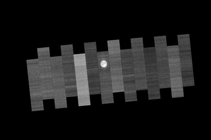
Once a month, during the full Moon, the spacecraft turns its instruments away from Earth and points them directly at the lunar surface. Over the course of two orbits, the spacecraft maneuvers to image the moon 15 times. During each pass, Landsat captures detailed measurements of light reflected off the Moon’s surface, revealing any unintended sensor change, or “drift,” that needs correction.
The animation above shows the scans acquired by band 4 of the OLI (Operational Land Imager) on Landsat 9 on January 3, 2026. Each parallel scan was acquired by one of the 14 detector modules that comprise the instrument’s focal plane. The satellite maneuvers so that each module images the Moon, with one module capturing it twice.
This work is one piece in a complex puzzle called calibration, which is part of what makes NASA the gold standard of science worldwide. From before launch all the way to the end of a satellite’s life, engineers ensure that the data collected by the satellite is accurate and consistent. In addition to looking to the Moon, Landsat also looks to places on Earth where the ground is uniform, like the wide, pale expanse of the White Sands desert in New Mexico.
Scientists also collect measurements on the ground to check against those collected from space. For example, they ensure that surface temperature readings match those recorded by Landsat’s thermal band. All these efforts are part of what make a Landsat image different from photos taken by consumer cameras. Landsat images contain crucial information that scientists can use to map changes in habitats, tree species, agricultural patterns, and more.
Video and animation by Ross Walter, using Landsat data from the U.S. Geological Survey. Story by Ross Walter and Madeleine Gregory, Landsat Project Science Support.
References & Resources
- Landsat Project Science Support (2025, December 16) Maintaining the Gold Standard: The Future of Landsat Calibration and Validation. Accessed May 22, 2026.
- NASA (2025, December 2) Calibration & Validation. Accessed May 22, 2026.
- NASA Earth Observatory (2022, July 5) Landsat Looks at the Moon. Accessed May 22, 2026.
- NASA’s Scientific Visualization Studio (2014, July 11) Landsat 8 Lunar Calibration. Accessed May 22, 2026.
You may also be interested in:
Stay up-to-date with the latest content from NASA as we explore the universe and discover more about our home planet.
The crew of NASA’s Artemis II mission captured extraordinary images of our home planet during their journey around the far…

A series of nighttime satellite images revealed how moonlight reaching Earth varied throughout a total lunar eclipse.
From autumn color to a winter-white finish, forested areas around Blacksburg trade foliage for snow over the span of two…














Related Posts


Stay Informed With the Latest & Most Important News
Previous Post
Next Post


Advertisement
-
 01Two Black Holes Observed Circling Each Other for the First Time
 -
 02From Polymerization-Enabled Folding and Assembly to Chemical Evolution: Key Processes for Emergence of Functional Polymers in the Origin of Life
 -
 03Astronomy 101: From the Sun and Moon to Wormholes and Warp Drive, Key Theories, Discoveries, and Facts about the Universe (The Adams 101 Series)
 -
 04True Anomaly hires former York Space executive as chief operating officer
 -
 05Φsat-2 begins science phase for AI Earth images
 -
 06Hurricane forecasters are losing 3 key satellites ahead of peak storm season − a meteorologist explains why it matters
 -
 07Binary star systems are complex astronomical objects − a new AI approach could pin down their properties quickly