
Now Reading: Data Fusion Provides a High-Definition Look At Mars’ Temperature Maps
-
01
Data Fusion Provides a High-Definition Look At Mars’ Temperature Maps


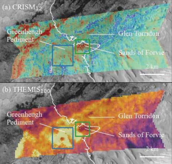
In-situ Resource Utilization (ISRU) is our best bet for “living off the land” for a future Martian base, but tracking down those resources is no easy task. As of now, we have two options – send a rover to a specific location to scout it, or monitor it from orbit. Since rovers are expensive, and there are an absolute ton of sites that we would eventually want to scout, doing so from orbit would seem a better option. But monitoring for temperature, one of the most important orbital scans we can do, is notoriously blurry – based in part on the fact that most of the main instruments used to collect data on it are a few decades old. Now, a paper from researchers at Curtin University in Australia presented at the International Astronautical Congress meeting last September uses a fancy AI-like algorithm to improve that thermal resolution, and, as a result, provided a much better map to some of the most important resources we’ll be looking for.


Related Posts


Stay Informed With the Latest & Most Important News
Previous Post
Next Post


Advertisement
-
 01Two Black Holes Observed Circling Each Other for the First Time
 -
 02From Polymerization-Enabled Folding and Assembly to Chemical Evolution: Key Processes for Emergence of Functional Polymers in the Origin of Life
 -
 03Astronomy 101: From the Sun and Moon to Wormholes and Warp Drive, Key Theories, Discoveries, and Facts about the Universe (The Adams 101 Series)
 -
 04True Anomaly hires former York Space executive as chief operating officer
 -
 05Φsat-2 begins science phase for AI Earth images
 -
 06Hurricane forecasters are losing 3 key satellites ahead of peak storm season − a meteorologist explains why it matters
 -
 07Binary star systems are complex astronomical objects − a new AI approach could pin down their properties quickly