
Now Reading: European imaging companies step in to fill warzone gap
-
01
European imaging companies step in to fill warzone gap


MILAN – As U.S. satellite imagery companies have pulled back from sharing visuals of Iran and the broader area around the Gulf conflict, European Earth-observation firms are moving to fill the vacuum.
The new business is coming from global energy traders, insurers, shipping firms and news organizations, all of whom depend on commercial satellite imagery to monitor one of the world’s most sensitive waterways: the Strait of Hormuz.
“In the energy sector, Earth observation data has become a core part of the business in the last five years,” Antoine Rostand, president and co-founder of French environmental intelligence company Kayrros, told SpaceNews.
“Since the war in Iran there has been even more interest in monitoring the situation, and it was very surprising for us to see that a flow of information previously coming from U.S. companies was suddenly cut off. It was a shock for everybody.”
The change began after several American Earth-observation providers restricted access to imagery tied to Iran and surrounding conflict areas.
On April 4, Planet Labs said it would indefinitely withhold imagery of Iran and the wider Middle East conflict region in response to a request from the Trump administration. The move followed similar restrictions by Vantor — formerly Maxar — and Satellogic, which added Iran to a list of areas subject to enhanced due diligence and limits on general commercial sales.
The decisions triggered concern among international media organizations including the BBC, CNN, Al Jazeera, The Washington Post and The New York Times, all of which rely on commercial satellite imagery to document military activity, shipping disruptions and infrastructure damage.
The restrictions came at a volatile moment.
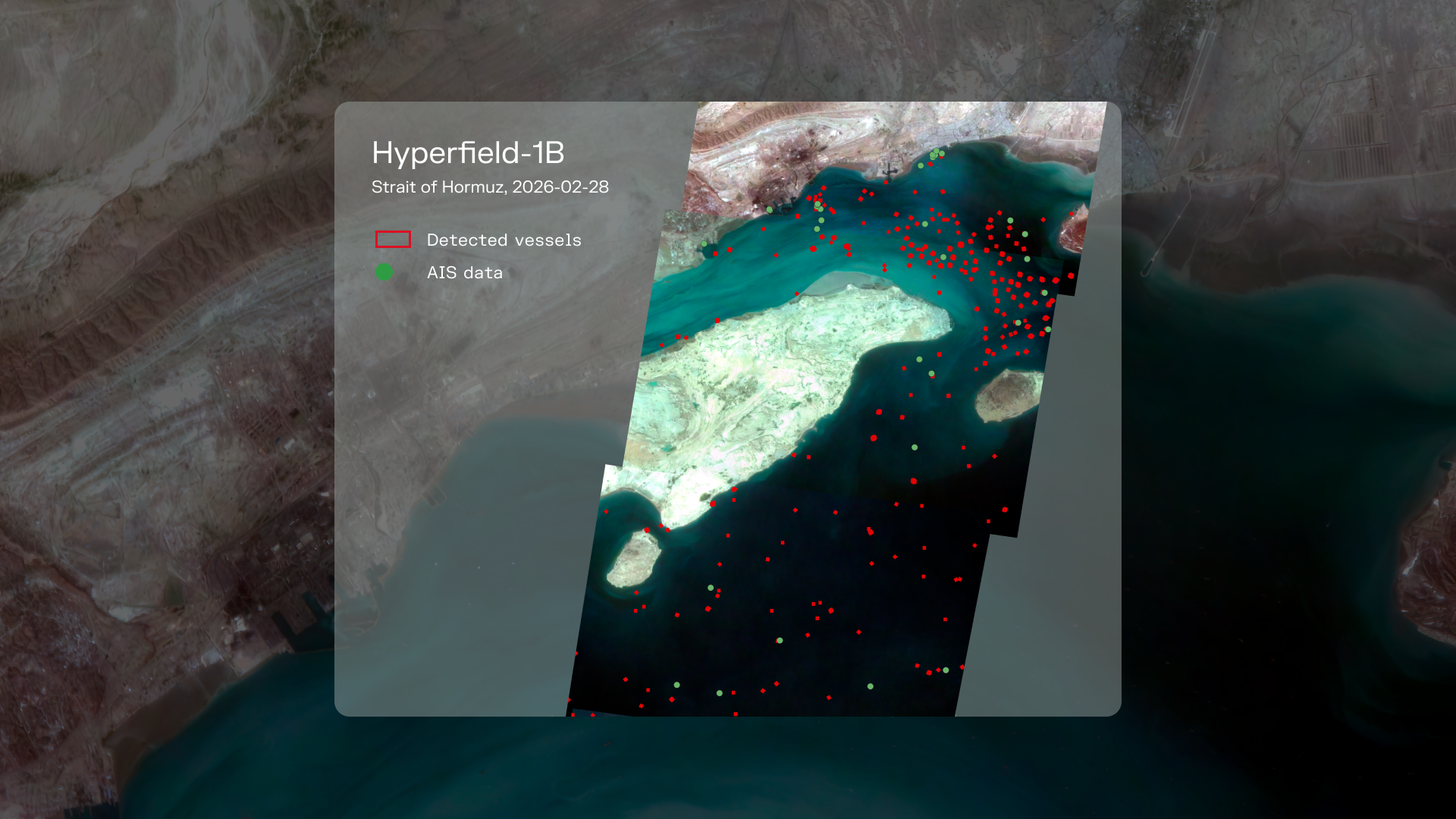
Since Iran blocked the Strait of Hormuz on Feb. 28, governments and commodity markets have scrambled for reliable information about vessel traffic through the narrow waterway connecting the Persian Gulf to the Arabian Sea. Roughly one-quarter of the world’s seaborne oil trade and about one-fifth of global liquefied natural gas shipments pass through the strait each year.
That meant oil traders wanted evidence of tanker movements. Shipping firms tracked vessels that had gone dark by disabling Automatic Identification System, or AIS, transponders. Airlines, insurers and commodity analysts looked for signs of disruption spreading through global supply chains.
“In the energy sector, Earth-observation data has become a core part of the business in the last five years,” Rostand said.
For European Earth-observation companies, industry leaders at the third ESA EO Commercialization Forum in Seville last week said the crisis created an opening.
Rostand said firms across the continent rushed to determine whether Europe could replace at least some of the imagery and analytics previously supplied by American providers. He pointed to the European Union’s Copernicus Earth-observation program, along with commercial operators such as Airbus and Italy’s e-GEOS, as evidence that Europe possesses as part of the solution.
“The good news is that in Europe we have Copernicus, which kept operating with no restrictions,” he said.
While larger operators absorbed much of the redirected commercial demand, smaller European firms also found themselves fielding new requests from media organizations and analysts seeking independent visibility into the conflict.
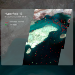
Finnish hyperspectral-imaging startup Kuva Space said it received more requests from U.S. news outlets searching for alternative sources of information about activity in the Strait of Hormuz.
“We saw an increase in interest from the media, especially U.S. media, which were trying to figure out what is really happening there because nobody else was providing that information,” said Malathy Eskola, the company’s commercial director.
One area of interest involved so-called “dark vessels” — ships traveling with AIS signals switched off to avoid detection.
According to Kuva Space data, as many as 97% of vessels moving through the strait had disabled AIS transponders by March 29, one month after the blockade was formally imposed.
News organizations also sought environmental analysis following strikes on oil infrastructure in the Gulf.
The episode also highlighted Europe’s remaining limitations, including near-real-time capabilities available from larger American operators.
Kuva, for example, expects next-generation satellites scheduled for launch later this year to improve processing speed and responsiveness.
The Gulf event also comes as the European space community focuses on sovereignty.
For years, European policymakers promoted the idea of reducing dependence on U.S. technologies. The sudden withdrawal of American imagery from a global conflict zone gave those concerns new urgency.
“This story really shows that strategic autonomy is not just a word, it is a reality,” Rostand said. “The fact that we are independent and autonomous is essential.”


Related Posts
Stay Informed With the Latest & Most Important News
Previous Post
Next Post


Advertisement
-
 01Two Black Holes Observed Circling Each Other for the First Time
 -
 02From Polymerization-Enabled Folding and Assembly to Chemical Evolution: Key Processes for Emergence of Functional Polymers in the Origin of Life
 -
 03Astronomy 101: From the Sun and Moon to Wormholes and Warp Drive, Key Theories, Discoveries, and Facts about the Universe (The Adams 101 Series)
 -
 04True Anomaly hires former York Space executive as chief operating officer
 -
 05Φsat-2 begins science phase for AI Earth images
 -
 06Hurricane forecasters are losing 3 key satellites ahead of peak storm season − a meteorologist explains why it matters
 -
 07Binary star systems are complex astronomical objects − a new AI approach could pin down their properties quickly