
Now Reading: Gabon’s Stunning Landscapes Revealed Through Advanced Satellite Imaging
-
01
Gabon’s Stunning Landscapes Revealed Through Advanced Satellite Imaging

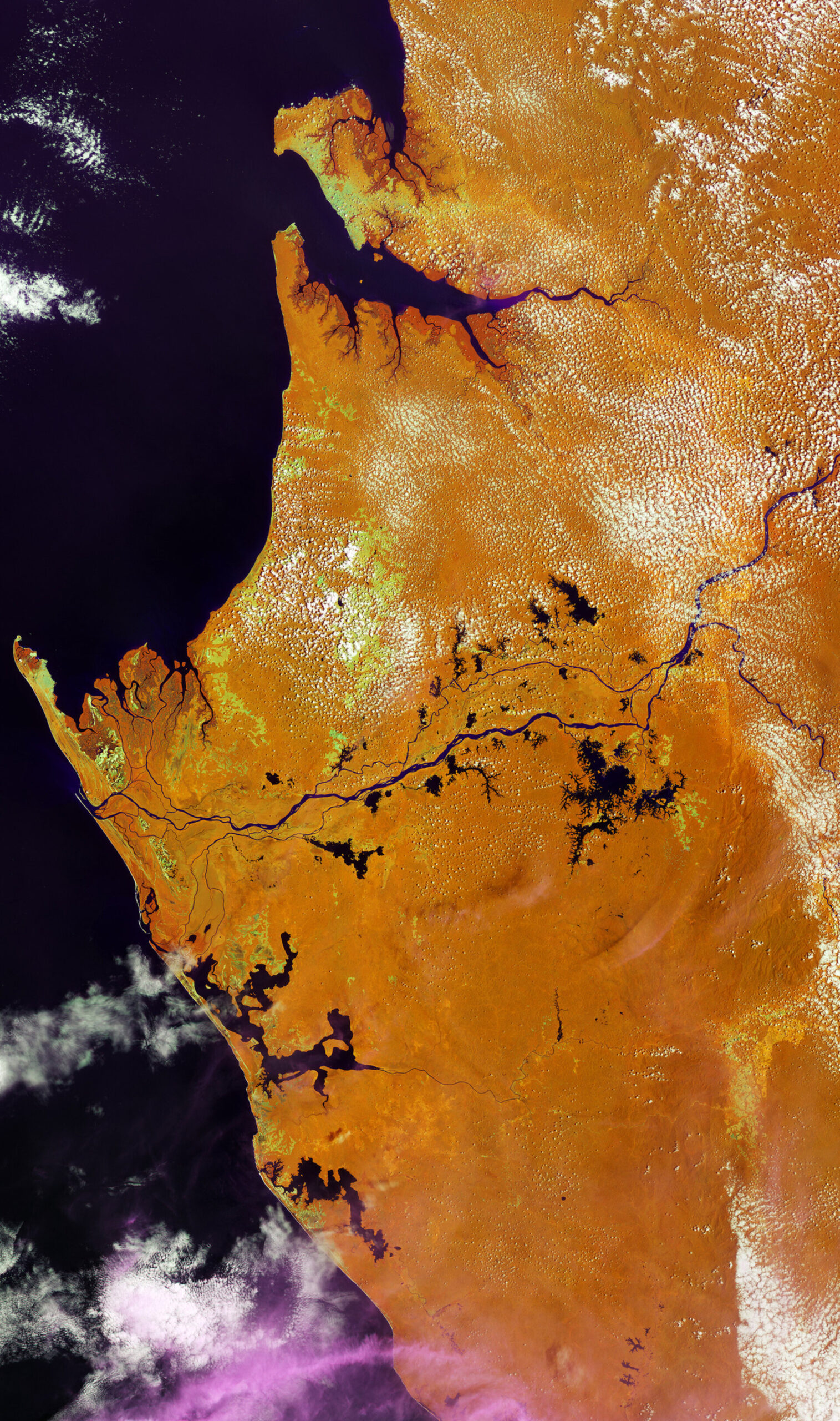

A stunning image from the Copernicus Sentinel-2 mission showcases the vibrant coastal region of Gabon, a country located in Central Africa. Bordered by Cameroon, the Republic of the Congo, and Equatorial Guinea, Gabon faces the Gulf of Guinea and is renowned for its expansive tropical forests, which account for approximately 88% of its landscape. These lush rainforests are known for their rich biodiversity, serving as a sanctuary for iconic wildlife, including the critically endangered forest elephants and the western lowland gorillas.
Gabon’s tropical climate, characterized by high humidity and heat, often results in cloud cover that complicates direct optical observations. However, the Sentinel-2 satellite is equipped with 13 spectral channels that assist in bypassing these atmospheric obstacles. The image used false-color techniques by highlighting selected near-infrared and short-wave spectral bands. This approach minimizes haze and enhances the contrast among various land covers and moisture levels, providing a clearer picture of the region’s vegetation and geography than traditional optical images would allow.
The processed image features a gradient of colors to represent different features: clouds vary in hues from white to pink, reflecting their altitudes and moisture content, while water bodies, such as rivers and lakes, stand out in dark shades. In contrast, the dense forests predominantly take on an orange hue, while areas of lower ground and high moisture show up in darker orange or brownish tones. The patches of yellow and acid green signify grasslands or bare soil, adding further detail to the landscape.
One of the central geographical elements is the Ogooué River, which meanders through the image, flowing westward into the Gulf of Guinea after traversing the country and gathering water from various lakes. Port Gentil, Gabon’s second-largest city, is located near this delta and close to Cape Lopez, the country’s westernmost point. Additionally, Gabon’s capital, Libreville, can be seen on the northern shore of the expansive Gabon Estuary, which is visible at the image’s upper section. This visual from the Sentinel-2 not only highlights Gabon’s striking natural beauty but also emphasizes the importance of advanced satellite technology in environmental monitoring and land management.


Related Posts

Stay Informed With the Latest & Most Important News
Previous Post
Next Post


Advertisement
-
 01Two Black Holes Observed Circling Each Other for the First Time
 -
 02From Polymerization-Enabled Folding and Assembly to Chemical Evolution: Key Processes for Emergence of Functional Polymers in the Origin of Life
 -
 03Astronomy 101: From the Sun and Moon to Wormholes and Warp Drive, Key Theories, Discoveries, and Facts about the Universe (The Adams 101 Series)
 -
 04True Anomaly hires former York Space executive as chief operating officer
 -
 05Φsat-2 begins science phase for AI Earth images
 -
 06Hurricane forecasters are losing 3 key satellites ahead of peak storm season − a meteorologist explains why it matters
 -
 07Binary star systems are complex astronomical objects − a new AI approach could pin down their properties quickly