
Now Reading: Quito’s Stunning Landscape Revealed Amidst Rising Concerns Over Drought and Wildfires
-
01
Quito’s Stunning Landscape Revealed Amidst Rising Concerns Over Drought and Wildfires

Quito’s Stunning Landscape Revealed Amidst Rising Concerns Over Drought and Wildfires
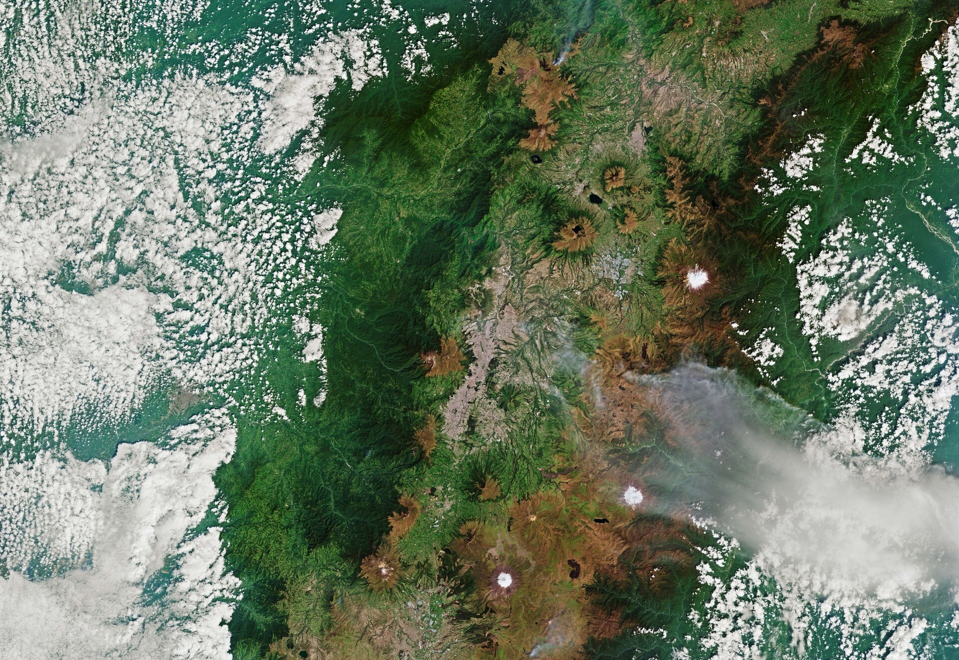

An image from the Copernicus Sentinel-2 mission showcases Ecuador’s capital, Quito, as it spans 40 kilometers within a high-altitude valley in the Andes. At an impressive elevation of 2,850 meters, Quito holds the distinction of being the only capital city situated in close proximity to an active volcano. The city is notably overlooked by Pichincha volcano to the west, with several other prominent peaks, including Cotopaxi, Antisana, and Cayambe, visible in the backdrop. Cotopaxi, which stands at about 5,900 meters, is not only the second highest mountain in Ecuador but also one of the country’s most active volcanoes.
In the heart of the image lies Quito, tucked within the Guayllabamba river basin. The southern neighborhoods are separated by the Machángara River, a tributary that flows northward through the city, passing by the notable Panecillo park. This hill offers stunning panoramic views of Quito’s historical center, which is distinguished by rooftops cast in reddish hues, marking it as a UNESCO World Heritage Site recognized for its remarkable architectural preservation.
The surrounding landscape is enriched with diverse biological habitats, from cloud forests to ecological sanctuaries like the Pululahua Geobotanical Reserve, identifiable in the image’s darker green patches situated just north of the urban area. To the east of Quito and the Guayllabamba valley, three national parks are draped in clouds, while to the west, the city of Santo Domingo is partially obscured by a white, cloud-cover.
However, not all is tranquil in this vibrant region. The year 2025 witnessed significant drought conditions that led to detrimental wildfires impacting various areas surrounding Quito. The image captures a sizeable smoke plume emanating from the east of the city and a smaller one to the north, close to the Sincholagua volcano. Significant scorched earth is apparent in the hills east of Quito, where nearly 200 hectares of high-altitude grasslands were devastated, particularly near the isolated Andean community of Oyacachi, within the boundaries of Cayambe Coca National Park.


Related Posts


Stay Informed With the Latest & Most Important News
Previous Post
Next Post


Advertisement
-
 01Two Black Holes Observed Circling Each Other for the First Time
 -
 02From Polymerization-Enabled Folding and Assembly to Chemical Evolution: Key Processes for Emergence of Functional Polymers in the Origin of Life
 -
 03Astronomy 101: From the Sun and Moon to Wormholes and Warp Drive, Key Theories, Discoveries, and Facts about the Universe (The Adams 101 Series)
 -
 04True Anomaly hires former York Space executive as chief operating officer
 -
 05Φsat-2 begins science phase for AI Earth images
 -
 06Hurricane forecasters are losing 3 key satellites ahead of peak storm season − a meteorologist explains why it matters
 -
 07Binary star systems are complex astronomical objects − a new AI approach could pin down their properties quickly