
Now Reading: Radar Images Reveal Dramatic Changes in Greenland Ice Sheet Amid Climate Concerns
-
01
Radar Images Reveal Dramatic Changes in Greenland Ice Sheet Amid Climate Concerns

Radar Images Reveal Dramatic Changes in Greenland Ice Sheet Amid Climate Concerns
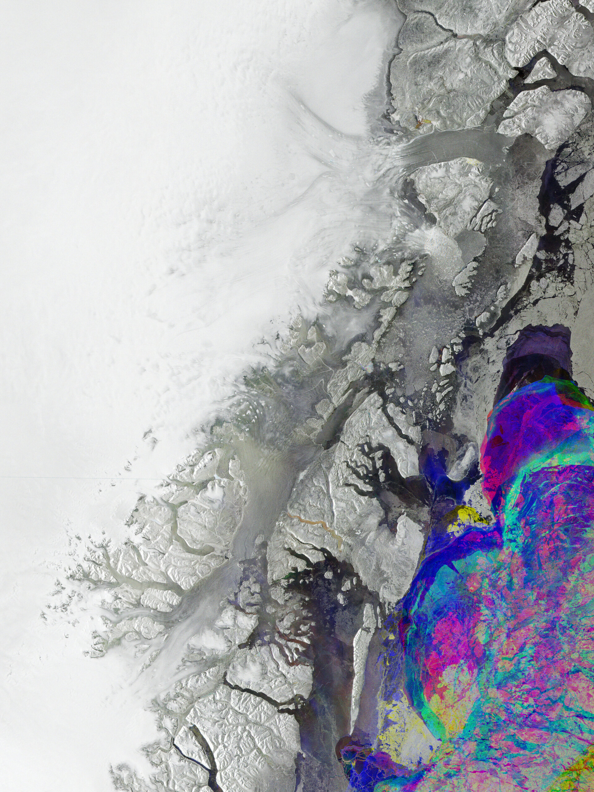

Northeastern Greenland’s rugged coastline has recently been captured in a striking radar image from the Copernicus Sentinel-1 satellite. This image showcases the world’s largest island, where approximately 80% of its landscape is cloaked by the Greenland Ice Sheet, the second largest ice formation globally after the Antarctic Ice Sheet. The dramatic visuals are the result of three separate radar scans taken between January and March 2026, with each scan represented in a unique color. This innovative technique reveals surface changes by layering the colors together, allowing a detailed view of the region’s ice and water dynamics.
In the image, stable ice is depicted in white, while varying shades of grey signify areas with minimal change. More vibrant colors highlight dynamic shifts, particularly in the water near the coast, illustrating the ongoing transformation of sea ice. The three prominent outlet glaciers identified in the image—the 79N (Nioghalvfjerdsfjorden), Zachariae Isstrøm to the north, and Storstrømmen to the south—serve as vital components of the Northeast Greenland Ice Stream (NEGIS), which is responsible for draining 12 to 17 percent of the Greenland Ice Sheet into the North Atlantic.
The effects of climate change are increasingly apparent, as the Greenland Ice Sheet experiences accelerated melting, posing significant risks to coastal areas that are susceptible to flooding and storm surges. Containing about 12% of the world’s glacier ice, the complete melting of this ice sheet could lead to a staggering rise in global sea levels by up to seven meters, with dire implications for many coastal regions worldwide. Additionally, increased freshwater influx from the melting ice may disrupt the Gulf Stream, potentially destabilizing climates across northern Europe and beyond.
To effectively track these changes, consistent monitoring of the ice sheet’s alteration and melting pace is critical. The Sentinel-1 satellites, which provide imagery of the entire globe every six days, play an important role in this effort. Equipped with advanced radar technology, these satellites can capture images in any weather condition, day or night, making them perfect for observing Greenland’s vast and often inaccessible regions, which frequently endure harsh weather and prolonged darkness. By using satellite observations, researchers can validate climate models regarding ice sheet melting, leading to more accurate forecasts on Greenland’s influence on future sea-level rise.


Related Posts


Stay Informed With the Latest & Most Important News
Previous Post
Next Post


Advertisement
-
 01Two Black Holes Observed Circling Each Other for the First Time
 -
 02From Polymerization-Enabled Folding and Assembly to Chemical Evolution: Key Processes for Emergence of Functional Polymers in the Origin of Life
 -
 03Astronomy 101: From the Sun and Moon to Wormholes and Warp Drive, Key Theories, Discoveries, and Facts about the Universe (The Adams 101 Series)
 -
 04True Anomaly hires former York Space executive as chief operating officer
 -
 05Φsat-2 begins science phase for AI Earth images
 -
 06Hurricane forecasters are losing 3 key satellites ahead of peak storm season − a meteorologist explains why it matters
 -
 07Binary star systems are complex astronomical objects − a new AI approach could pin down their properties quickly