
Now Reading: Satellite Image Reveals Stunning Cloud Formations Over Tenerife and La Gomera
-
01
Satellite Image Reveals Stunning Cloud Formations Over Tenerife and La Gomera

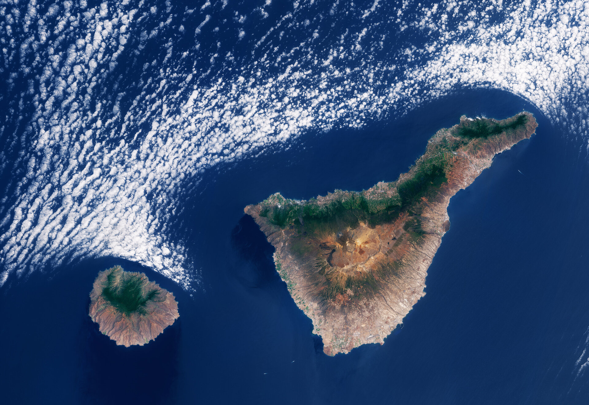

A recent image captured by the Copernicus Sentinel-2 satellite showcases a striking cloud formation to the north of Spain’s Canary Islands, specifically near Tenerife and La Gomera. The Canary Islands, recognized for their volcanic origins dating back millions of years, lie in the North Atlantic Ocean, approximately 100 kilometers from the African coast and are the southernmost territory of Spain. The archipelago includes seven major islands, with La Gomera and Tenerife being among the most prominent, alongside numerous smaller islets.
La Gomera, noticeable on the left side of the image, is characterized by its circular shape, rugged coastline, and a mountainous landscape. The island is home to the Garajonay National Park, where the Garajonay Peak, the highest elevation on La Gomera, rises centrally amidst rich and varied vegetation. San Sebastián de la Gomera, situated on the eastern shore facing Tenerife, serves as the island’s primary port and capital.
In contrast, Tenerife, the largest of the Canary Islands, is dominated by El Teide volcano, which stands at approximately 3,718 meters, making it the tallest peak in Spanish territory. The island features urban development along its coasts, with Santa Cruz de Tenerife located on the northeastern side, Puerto de la Cruz to the north, and Tenerife South Airport positioned on the southern coast.
Both Tenerife and La Gomera experience a variety of microclimates due to their diverse landscapes and climatic conditions. Consequently, visitors can enjoy warm and sun-drenched beaches in the south, lush and wetter regions in the north, and even cooler, snowy conditions at higher elevations, all within a short drive from one another. The trade winds, which dominate the area’s weather patterns, primarily blow from the northeast, contributing humidity and precipitation to the northern sections of the islands.
This climatic phenomenon is vividly illustrated in the satellite image, which captures the stark differences between the verdant northern landscapes and the drier southern regions of both islands. The interaction of these trade winds with the islands’ abrupt topography gives rise to unique cloud formations, particularly the marine stratocumulus clouds that are evident along the northern coasts. As these cool, moist winds approach the warmer land, they condense into cloud cover below 1,500 meters, and upon contacting the warmer surfaces, the cloud droplets evaporate, tracing the contours of the islands’ coastlines.


Related Posts


Stay Informed With the Latest & Most Important News
Previous Post
Next Post


Advertisement
-
 01Two Black Holes Observed Circling Each Other for the First Time
 -
 02From Polymerization-Enabled Folding and Assembly to Chemical Evolution: Key Processes for Emergence of Functional Polymers in the Origin of Life
 -
 03Astronomy 101: From the Sun and Moon to Wormholes and Warp Drive, Key Theories, Discoveries, and Facts about the Universe (The Adams 101 Series)
 -
 04True Anomaly hires former York Space executive as chief operating officer
 -
 05Φsat-2 begins science phase for AI Earth images
 -
 06Hurricane forecasters are losing 3 key satellites ahead of peak storm season − a meteorologist explains why it matters
 -
 07Binary star systems are complex astronomical objects − a new AI approach could pin down their properties quickly