
Now Reading: Spring Rains Saturate Michigan
-
01
Spring Rains Saturate Michigan


April 16, 2025
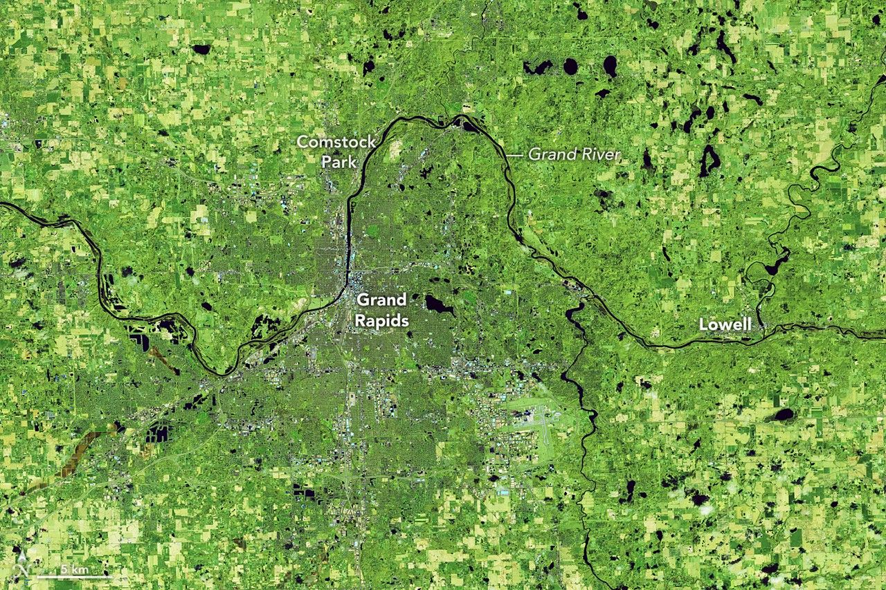
April 11, 2026
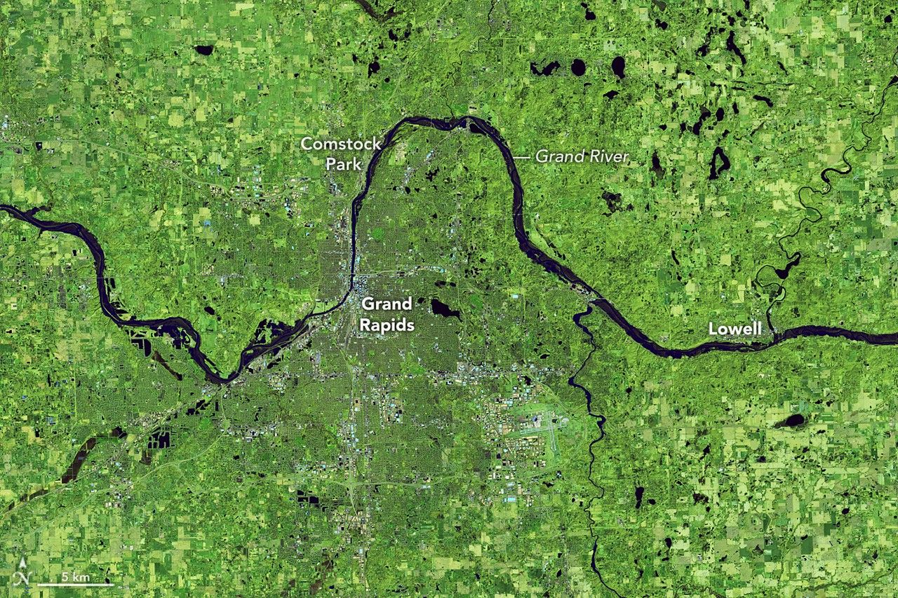
The start of spring 2026 brought bouts of heavy rain to much of Michigan. Above-normal levels of precipitation in March and early April—exacerbated by snowmelt in the northern part of the state—saturated soils and caused damaging flooding along multiple rivers. A flood watch spanned the entirety of both the upper and lower peninsulas as rain continued to fall in mid-April.
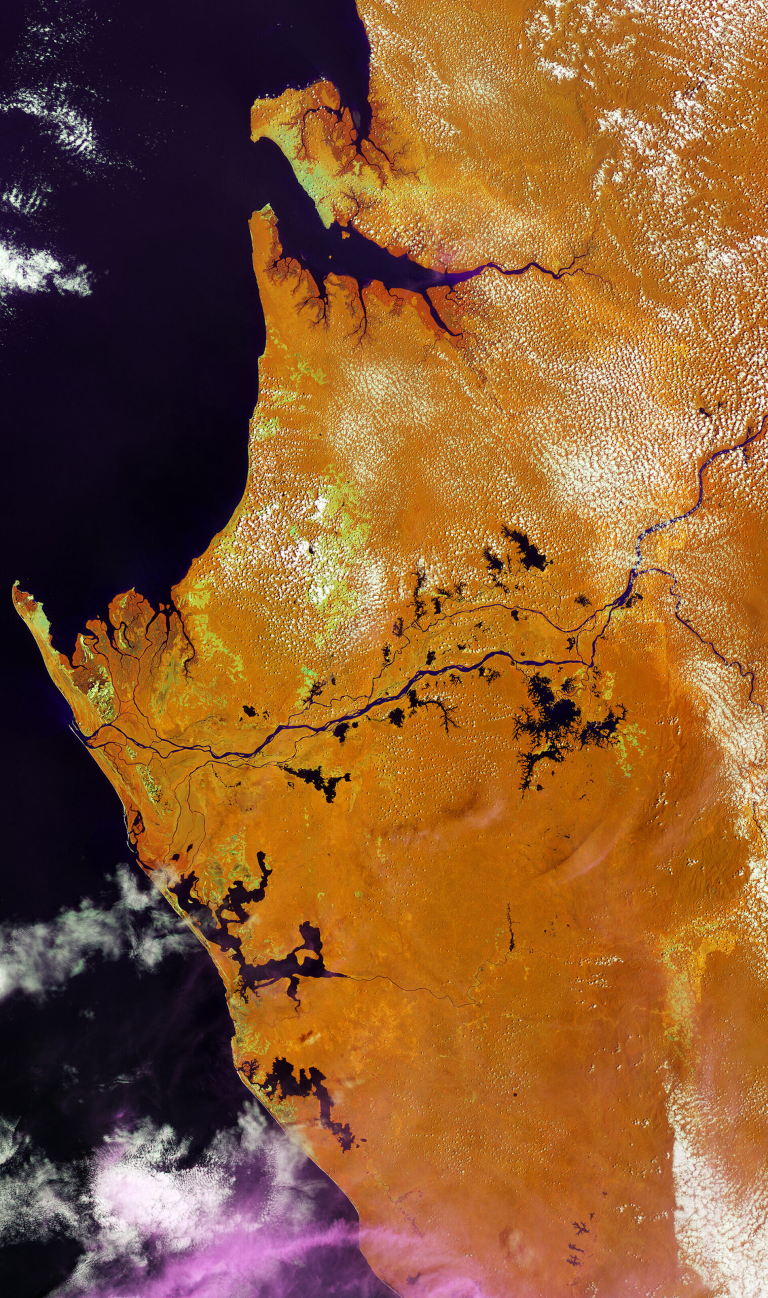
Flooding along the Grand River—Michigan’s longest—near Grand Rapids is visible in the image above (right), acquired on April 11, 2026. For comparison, the left image shows the area the previous April. The images are false-color to better distinguish water from vegetation and other land cover.
At the time of the 2026 image, river gauge data showed the Grand River at Comstock Park was in minor flood stage. The river had crested on April 8 at about half a foot beneath the major flood level at this gauge, making it one of the harder-hit locations along the river. Water had already submerged roads and trails along its banks and encroached on homes, according to news reports, and more water was still to come. After another round of rain, the river was rising again as of April 16, with the potential to reach one of the highest levels on record in Grand Rapids.
The area has been beset by many weeks of soggy weather. Grand Rapids saw approximately double the normal March rainfall totals in 2026. In the first half of April, it received 5.79 inches (147 millimeters), exceeding the average for the entire month by nearly 2 inches.
The story is similar throughout the state. To the north, where an above-normal snowpack still covered the ground, abundant rainfall combined with melt to amplify flooding. Floodwaters in the northern Lower Peninsula washed out roads, including part of a scenic drive, and rendered airport runways unusable. The buildup of water has also stressed dams around the state. Officials have been monitoring several reservoirs that are close to overtopping and have advised some residents to prepare to evacuate.
NASA Earth Observatory images by Lauren Dauphin, using Landsat data from the U.S. Geological Survey. Story by Lindsey Doermann.
References & Resources
- Bridge Michigan (2026, April 16) Michigan flood watch: Newaygo urges evacuations; Cheboygan Dam waters rise. Accessed April 16, 2026.
- FOX 17 (2026, April 5) Grand River forecast to reach major flood stage near Comstock Park. Accessed April 16, 2026.
- MLive (2026, April 15) All of Michigan under Flood Watch as roads washed out, dams fail, people evacuated. Accessed April 16, 2026.
- The New York Times (2026, April 15) Dam Failure Could Imperil Thousands in Northern Michigan. Accessed April 16, 2026.
- NOAA (2026) National Water Prediction Service. Accessed April 16, 2026.
- WGRD (2026, April 15) How the Current Grand River Flood Ranks Historically. Accessed April 16, 2026.
You may also be interested in:
Stay up-to-date with the latest content from NASA as we explore the universe and discover more about our home planet.

A potent atmospheric river delivered intense rainfall to western Washington, triggering flooding and mudslides.

Ice in the Hudson River hugged the shore of Manhattan amid a deep freeze.

Villages and farmland were swamped after unusually heavy early-February rains pushed the Sinú River over its banks.


Related Posts


Stay Informed With the Latest & Most Important News
Previous Post
Next Post


Advertisement
-
 01Two Black Holes Observed Circling Each Other for the First Time
 -
 02From Polymerization-Enabled Folding and Assembly to Chemical Evolution: Key Processes for Emergence of Functional Polymers in the Origin of Life
 -
 03Astronomy 101: From the Sun and Moon to Wormholes and Warp Drive, Key Theories, Discoveries, and Facts about the Universe (The Adams 101 Series)
 -
 04True Anomaly hires former York Space executive as chief operating officer
 -
 05Φsat-2 begins science phase for AI Earth images
 -
 06Hurricane forecasters are losing 3 key satellites ahead of peak storm season − a meteorologist explains why it matters
 -
 07Binary star systems are complex astronomical objects − a new AI approach could pin down their properties quickly