
Now Reading: Ukrainian forces test direct-to-device satellite imagery for frontline troops
-
01
Ukrainian forces test direct-to-device satellite imagery for frontline troops

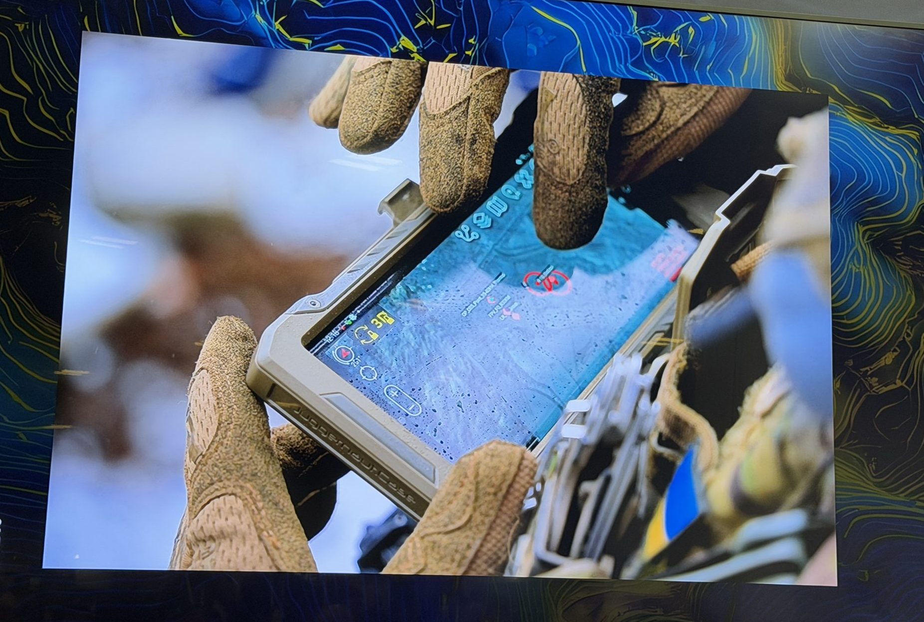

DENVER — In an experiment, Ukrainian forces used handheld devices to task commercial imaging satellites, bypassing centralized intelligence workflows that typically slow delivery to the battlefield.
Earth intelligence firm Vantor, formerly known as Maxar Intelligence, conducted the experiment as a demonstration of how satellite intelligence could be delivered directly to frontline operators.
“That imagery was transmitted and delivered to them in near real time,” said Susanne Hake, senior vice president and general manager of Vantor’s U.S. government business.
The imagery was also shared simultaneously with other units operating hundreds of kilometers away, allowing distributed teams to coordinate targeting decisions, Hake said at the GEOINT Symposium.
This type of technology is now being sought by defense and intelligence agencies amid a surge in commercially available data from satellites, drones and other sensors. While collection capabilities have expanded rapidly, getting that data to users in time to act on it remains a bottleneck.
“We have more imagery, more sensors, more phenomenology, more data than ever before,” Hake said. “But the reality is, much of that data still isn’t reaching the people who need it, fast enough.” The problem is not data collection, she added. “It’s really everything that happens after collection. It’s latency and bandwidth, systems that don’t talk to each other, workflows that are still depending on moving data from one place to another before it actually becomes useful.”
In the Ukraine test, software stitched together what are typically separate steps — tasking satellites, delivering imagery, integrating data and analyzing it — into a single workflow accessible at the tactical level. Units were able to identify targets, execute strikes and then quickly retask satellites for battle damage assessment.
A process that typically unfolds in sequence over hours was compressed into a continuous loop.
“And the impact of that was really significant. Targeting cycles that used to take days are now reduced to hours, and high value targets are able to be identified and acted on faster,” Hake said.
The ability to move intelligence directly to frontline units also reduced reliance on drones, which are vulnerable to air defenses, she said.
The concept of delivering intelligence “at the edge” has become a focal point for military planners, though the definition varies depending on the user. For soldiers, the edge may mean the front line; for intelligence agencies, it could refer to forward-deployed analysts or regional hubs.
“How you define the edge is really critical when you think about ‘where does the system actually break?’,” Hake said. “And in general, what we’re seeing is the system breaking before information gets out to the operator.”
That breakdown reflects deeper structural challenges. Much of the U.S. intelligence architecture still depends on centralized processing, with large volumes of raw data moving across networks before being analyzed. In contested environments, those networks are vulnerable to disruption, and bandwidth is often limited.
Officials at the National Geospatial-Intelligence Agency say the issue ultimately comes down to timeliness. Intelligence that arrives late has little operational value.
“We can’t carry everything. It has to be prioritized,” said Mark Chatelain, NGA’s chief information officer. “Being able to operate systems without being connected back to the mothership has been a big problem that NGA has faced for a long time.”
Technical and operational changes
NGA is exploring ways to move data into remote areas despite limited infrastructure, including more aggressive data compression and the use of artificial intelligence to determine what information should be transmitted.
“Where there is limited connectivity, you have to have aggressive compression of data,” Chatelain said. He added that AI systems may need to adapt dynamically based on available bandwidth, stepping in to prioritize and process data when communications are disrupted.
In response to these needs, a group of defense and technology firms at GEOINT announced a new effort bringing together companies focused on analytics, cloud infrastructure and connectivity to process and deliver intelligence directly in the field.
Vantor developed software that can help bridge the gap between collection and action, Hake said. “The next breakthrough in geoint is really about software, not just sensors.”
Even with advances in commercial technology, integrating data across legacy systems remains difficult, she said. New tools must fit into existing workflows and operate within the constraints of deployed environments, including outdated hardware and intermittent connectivity.
Hake said the company is now testing tools designed to compress the full cycle — from satellite tasking to data delivery — into less than 15 minutes. But limitations remain, particularly with large data products such as 3D imagery, which must be scaled down to function over constrained networks.
“We need to be really thoughtful about a particular area or size in order to get it onto a tactical device,” she said.


Related Posts


Stay Informed With the Latest & Most Important News
Previous Post
Next Post


Advertisement
-
 01Two Black Holes Observed Circling Each Other for the First Time
 -
 02From Polymerization-Enabled Folding and Assembly to Chemical Evolution: Key Processes for Emergence of Functional Polymers in the Origin of Life
 -
 03Astronomy 101: From the Sun and Moon to Wormholes and Warp Drive, Key Theories, Discoveries, and Facts about the Universe (The Adams 101 Series)
 -
 04True Anomaly hires former York Space executive as chief operating officer
 -
 05Φsat-2 begins science phase for AI Earth images
 -
 06Hurricane forecasters are losing 3 key satellites ahead of peak storm season − a meteorologist explains why it matters
 -
 07Binary star systems are complex astronomical objects − a new AI approach could pin down their properties quickly