
Now Reading: Tracy Arm’s Post-Tsunami Landscape
-
01
Tracy Arm’s Post-Tsunami Landscape


July 26, 2025
August 19, 2025
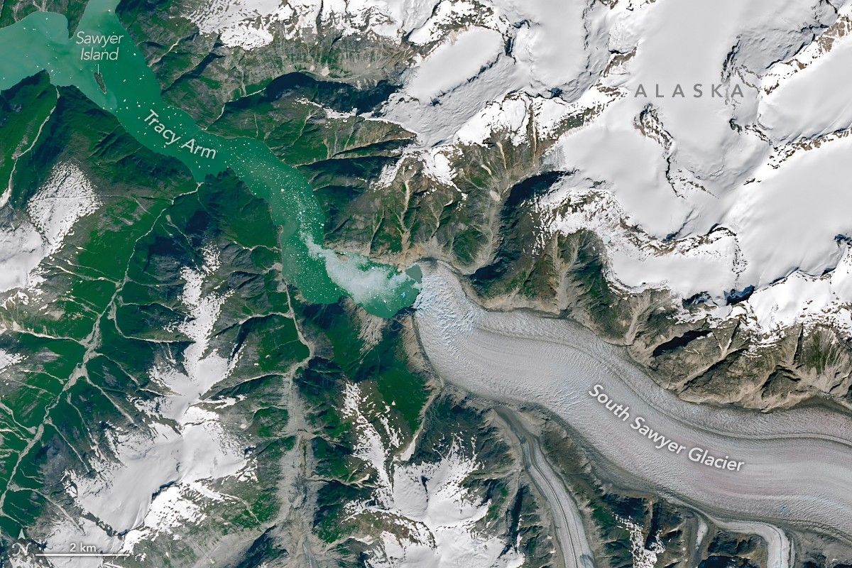
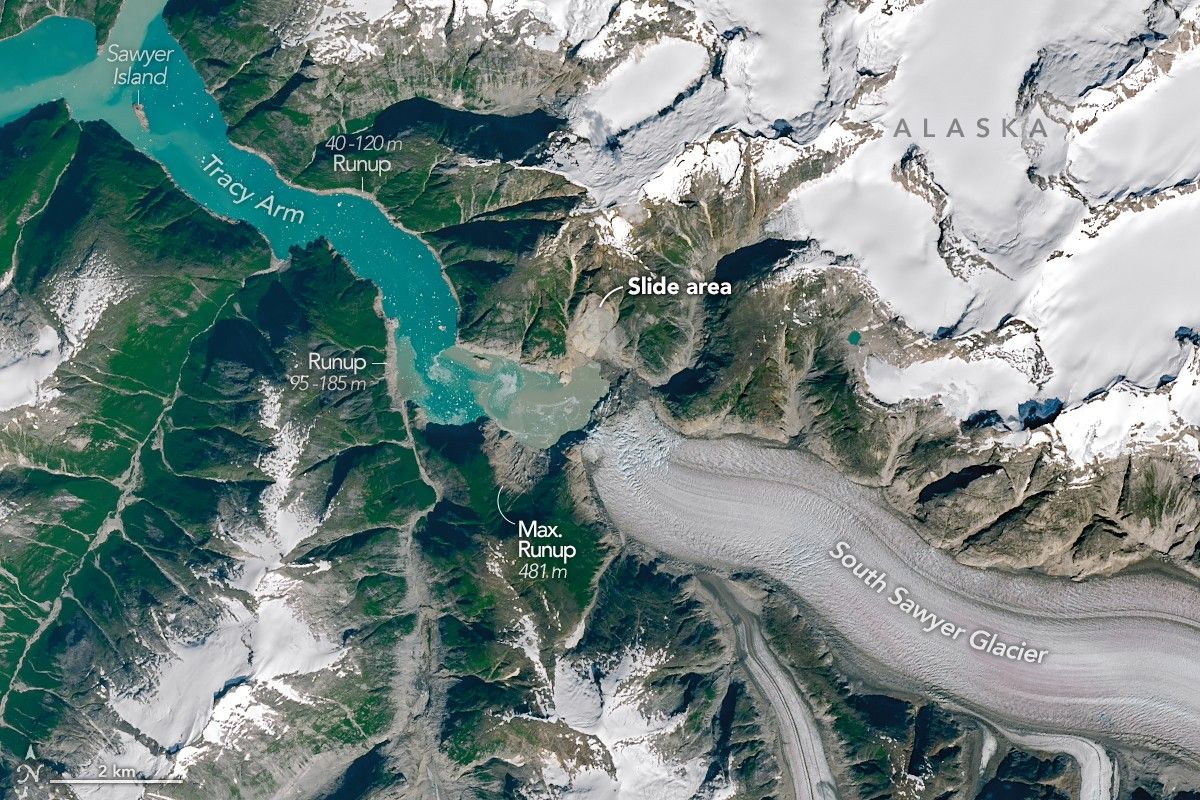
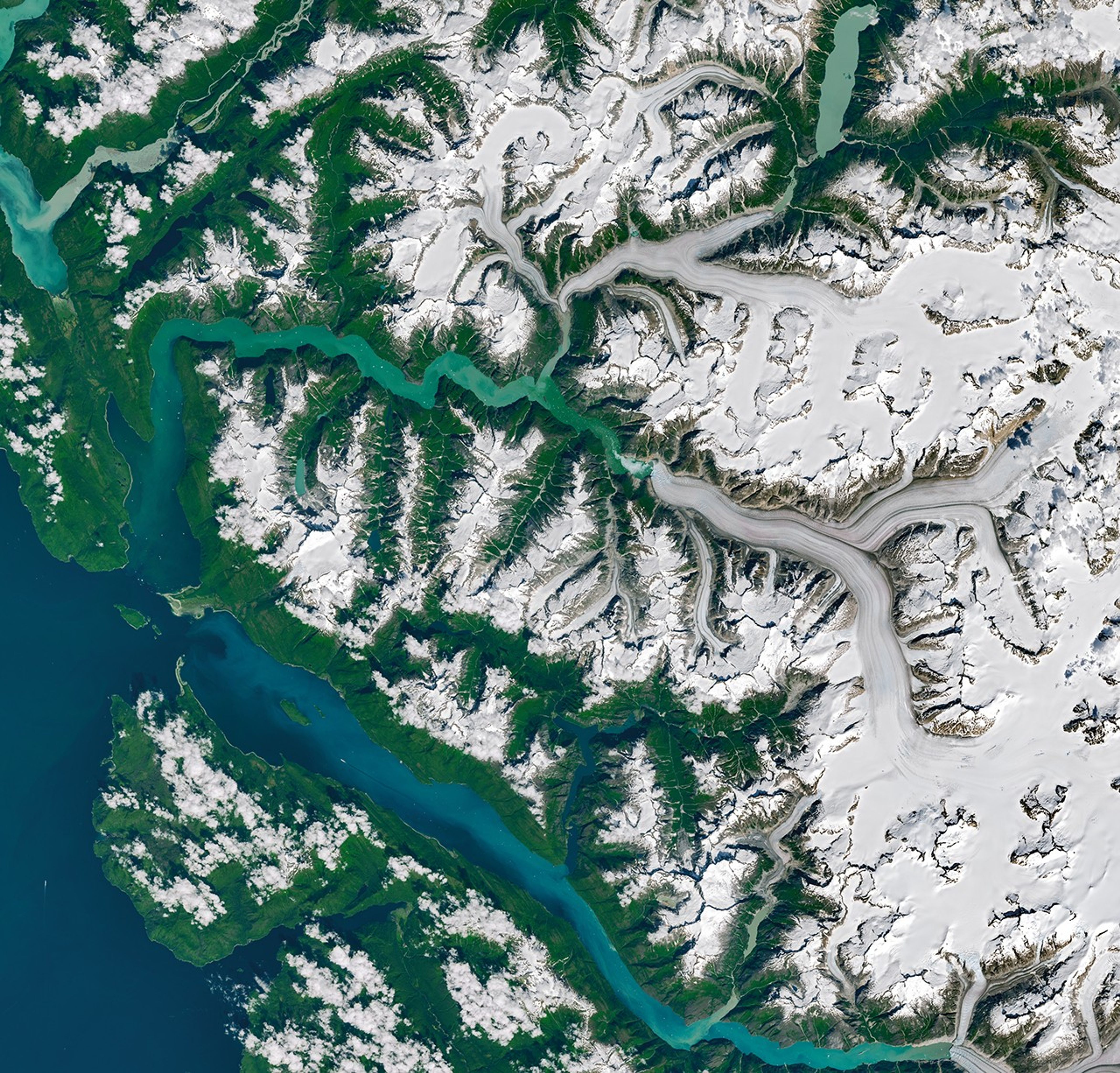
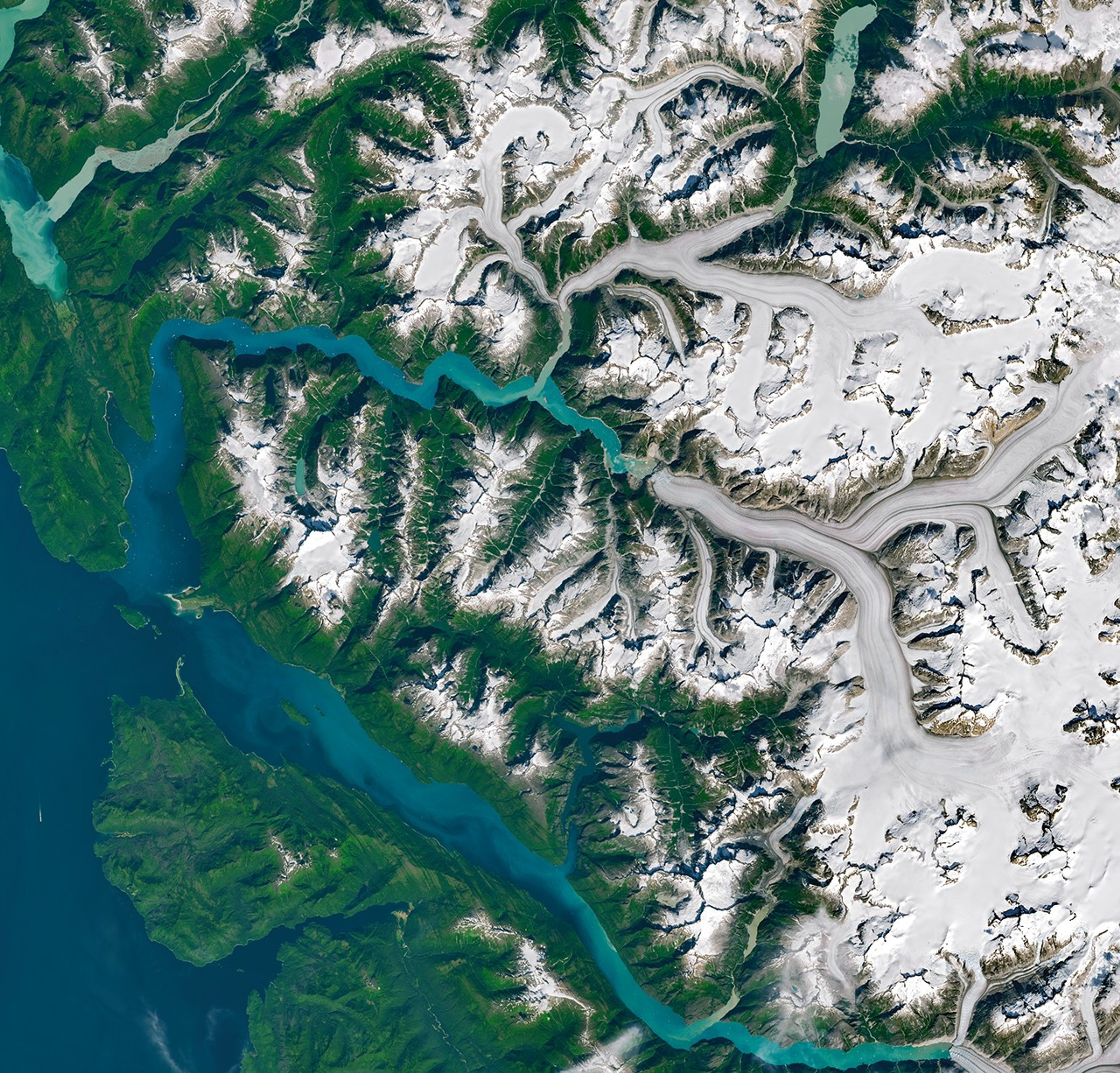
Carved over millennia by the pressure and motion of glacial ice, the valley walls cradling the Tracy Arm fjord in southeast Alaska continue to be reshaped. In summer 2025, following the rapid retreat of South Sawyer Glacier, a large landslide sent rock careening into the fjord, altering the wider landscape in a matter of minutes.
The slide culminated on the morning of August 10, 2025, when at least 64 million cubic meters of rock slid downslope. Material entering the fjord induced a tsunami that stripped trees and other vegetation from the opposing fjord wall up to 1,578 feet (481 meters) above sea level. While this peak was the highest “runup” reached by the tsunami, shores and islands down the fjord also saw substantial destruction.
NASA-USGS Landsat satellites captured these images on July 26 (left) and August 19 (right), before and after the event, respectively. “The bright landslide scar on the north side of the fjord is striking, as is the ‘bathtub’ ring around the fjord showing the areas where the forest was leveled by the tsunami,” said Dan Shugar, a geomorphologist at the University of Calgary.
Note that Sawyer Island, about 6 miles (9 kilometers) from the landslide, also turned from green to brown. Only a few trees still stood at the island’s higher elevations.

In the months following the slide, Shugar and colleagues combined satellite, airborne, and ground-based observations with eyewitness reports and simulations to build a more complete picture of how the event unfolded. Their analysis, detailing the event from its lead-up through its aftermath, was published May 6, 2026, in the journal Science.
In addition to the details outlined above, the researchers showed that water continued to slosh around the fjord—a phenomenon known as a “seiche”—for more than a day. Both the landslide and seiche produced seismic signals detected around the world, the former equivalent to a magnitude 5.4 earthquake.
The Landsat images also reveal significant retreat at the front of South Sawyer Glacier in less than a month. “Part of that occurred between the date of the first image and the date of the landslide,” Shugar said. “But part of it is from the landslide itself, which broke off a big chunk of the terminus of South Sawyer Glacier, resulting in a slurry of icebergs in the fjord.”
The exact mechanisms that caused the landslide remain uncertain and could have involved a combination of factors. Rainfall, which was moderate prior to the event, and the rapid retreat of glaciers can both destabilize a slope. What is clear, however, is that the glacier’s retreat exposed a new area of open water, leaving it vulnerable to a landscape-reorganizing tsunami.
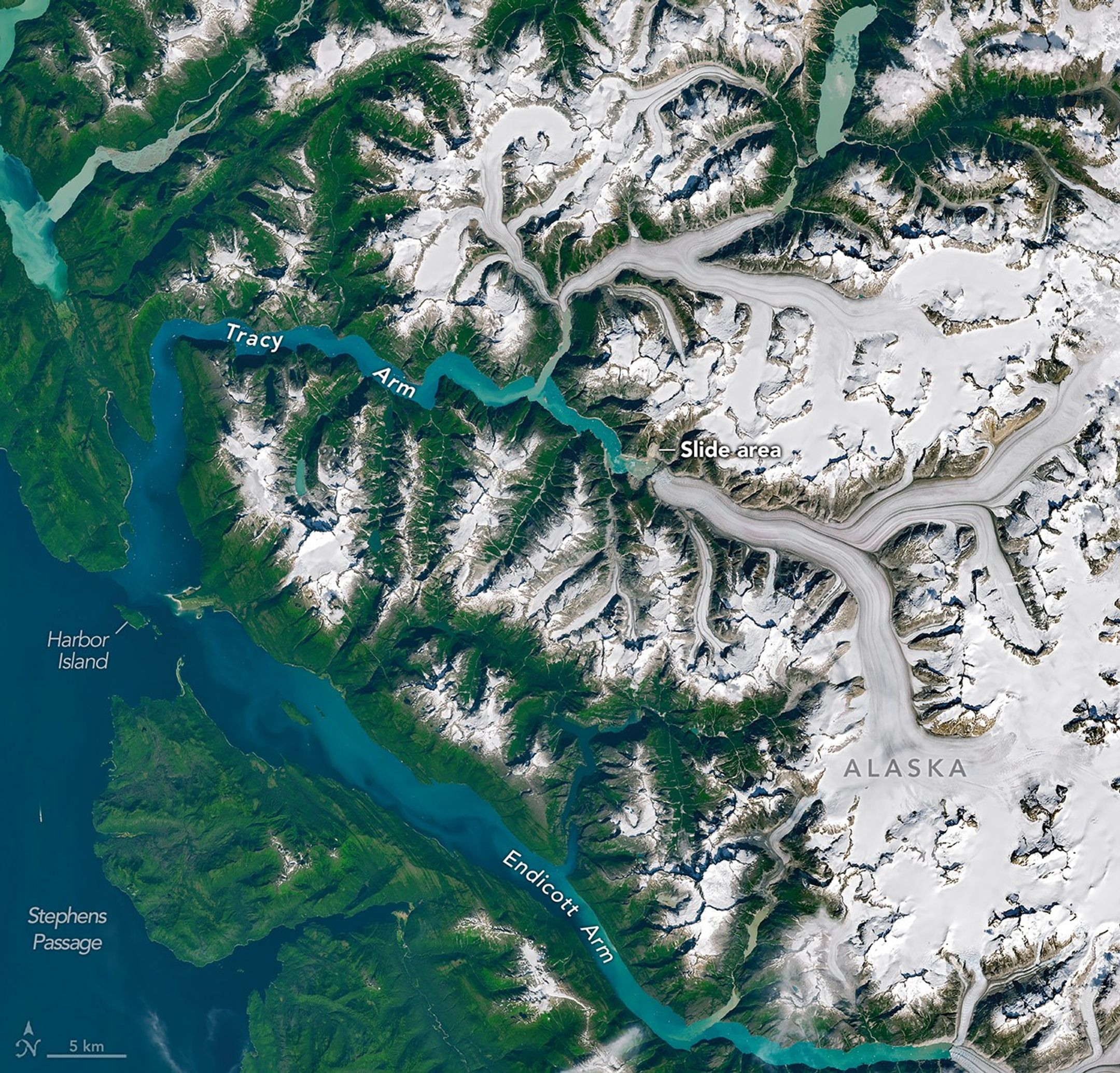
No one was injured in the event, though it did catch some by surprise. Kayakers camping on Harbor Island near the fjord’s mouth had their gear swept away, and passengers aboard a small cruise vessel in neighboring Endicott Arm reported swings in water levels and a strong current associated with the tsunami. Brentwood Higman of Ground Truth Alaska, a co-author of the paper, noted that a glacier’s shift from relative stability to renewed retreat, visible in satellite images, could serve as an important indicator that an area has become more susceptible to landslide and tsunami hazards.
NASA Earth Observatory images by Michala Garrison, using Landsat data from the U.S. Geological Survey. Photograph by John Lyons/U.S. Geological Survey. Story by Kathryn Hansen.
References & Resources
- Alaska Public Media (2025, August 12) ‘Pure chaos out of nowhere’: Mega-landslide and tsunami rip through Tracy Arm south of Juneau. Accessed May 7, 2026.
- AP News (2026, April 12) Cruise companies to Alaska are avoiding a popular excursion to Tracy Arm after a massive landslide. Accessed May 7, 2026.
- NASA Earth Observatory (2024, November 12) Sizing Up a Greenland Tsunami. Accessed May 7, 2026.
- Shugar, D. H., et al. (2026) A 481-meter-high landslide-tsunami in a cruise ship–frequented Alaska fjord. Science, 392 (6798).
- University of Alaska Fairbanks (2025, August 12) Tsunami-causing slide was largest in decade, earthquake center finds. Accessed May 7, 2026.
- U.S. Geological Survey (2025, August 13) 2025 Tracy Arm Landslide Before and After Satellite Imagery. Accessed May 7, 2026.
You may also be interested in:
Stay up-to-date with the latest content from NASA as we explore the universe and discover more about our home planet.

Satellite-based radar images show where a powerful earthquake in the Yukon, Canada, sent rock, snow, and ice spilling across the…

Heavy rains from Tropical Cyclone Maila triggered a deadly landslide in the mountains of East New Britain.

Scientists relied on satellite data to understand how the Antarctic glacier lost so much ice so rapidly.


Related Posts


Stay Informed With the Latest & Most Important News
Previous Post
Next Post


Advertisement
-
 01Two Black Holes Observed Circling Each Other for the First Time
 -
 02From Polymerization-Enabled Folding and Assembly to Chemical Evolution: Key Processes for Emergence of Functional Polymers in the Origin of Life
 -
 03Astronomy 101: From the Sun and Moon to Wormholes and Warp Drive, Key Theories, Discoveries, and Facts about the Universe (The Adams 101 Series)
 -
 04True Anomaly hires former York Space executive as chief operating officer
 -
 05Φsat-2 begins science phase for AI Earth images
 -
 06Hurricane forecasters are losing 3 key satellites ahead of peak storm season − a meteorologist explains why it matters
 -
 07Binary star systems are complex astronomical objects − a new AI approach could pin down their properties quickly