
Now Reading: Mars Express Reveals the Geologic Wonders of Shalbatana Vallis
-
01
Mars Express Reveals the Geologic Wonders of Shalbatana Vallis

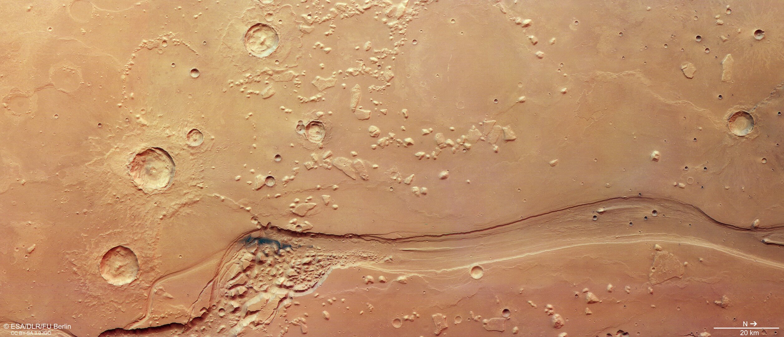

ESA’s Mars Express has recently turned its gaze toward Shalbatana Vallis, a captivating Martian valley that showcases the planet’s complex geological history characterized by signs of water, volcanic activity, and impact craters. This substantial channel, which stretches approximately 1,300 kilometers—or roughly the length of Italy—lies near Mars’s equator. The latest images from Mars Express’s High Resolution Stereo Camera (HRSC) focus on the northern section of this meandering valley.
The exploration of Shalbatana Vallis includes a video journey released in October 2025, illustrating the channel’s path from the highland region of Xanthe Terra to the smoother lowlands of Chryse Planitia. Scientists believe this valley formed around 3.5 billion years ago, when groundwater surged to the Martian surface, leading to catastrophic flooding that sculpted the landscape into the winding, water-worn formations we see today. The main section of the valley measures about 10 kilometers in width and reaches depths of up to 500 meters, as depicted in a detailed topographical view.
Over the eons, Shalbatana Vallis has experienced considerable geological change, losing depth due to the accumulation of various materials. Among the more recent deposits visible in the valley is a patch of blue-black volcanic ash, likely redistributed by Martian winds. This isolated remnant can be seen amidst the uneven terrain, which has transitioned from a once-deeper valley filled with water flow to a more chaotic arrangement of rock.
Shalbatana Vallis is part of a network of valleys that separate the heavily cratered southern highlands of Mars from the smoother northern lowlands. Just beyond the frame is Chryse Planitia, which is among the lowest regions on the planet. The presence of numerous large outflow channels that converge here has led researchers to theorize that this area may have once hosted a substantial ocean during Mars’s warmer, wetter periods.
The terrain of Shalbatana Vallis is also marked by chaotic regions—areas characterized by a jumbled assortment of rock blocks and mounds. These chaotic terrains likely form when subsurface water ice melts, causing the overlying ground to collapse. This phenomenon has been documented in other Martian regions and is an example of the dynamic processes shaping the planet.
Additionally, various impact craters dot the landscape, with some partially buried or eroded over time. The extensive lava flows in the area have smoothed the surface, with geological features such as wrinkle ridges emerging as the lava cooled and contracted. Isolated mesas remain as remnants of the once higher terrain that has been worn down through geological processes.
The images and data from Shalbatana Vallis are part of the ongoing Mars Express mission, which has been providing high-resolution, three-dimensional views of the Martian surface since its launch in 2003. Operated by the German Aerospace Center (DLR), Mars Express continues to reveal critical insights about Mars, enriching our understanding of the planet’s history and geological makeup.


Related Posts


Stay Informed With the Latest & Most Important News
Previous Post
Next Post
Previous Post
Next Post


Advertisement
-
 01Two Black Holes Observed Circling Each Other for the First Time
 -
 02From Polymerization-Enabled Folding and Assembly to Chemical Evolution: Key Processes for Emergence of Functional Polymers in the Origin of Life
 -
 03Astronomy 101: From the Sun and Moon to Wormholes and Warp Drive, Key Theories, Discoveries, and Facts about the Universe (The Adams 101 Series)
 -
 04True Anomaly hires former York Space executive as chief operating officer
 -
 05Φsat-2 begins science phase for AI Earth images
 -
 06Hurricane forecasters are losing 3 key satellites ahead of peak storm season − a meteorologist explains why it matters
 -
 07Binary star systems are complex astronomical objects − a new AI approach could pin down their properties quickly